A state of emergency has been declared on the West Coast, on Tuesday night, with heavy rain likely to cause significant flooding and dangerous river conditions.
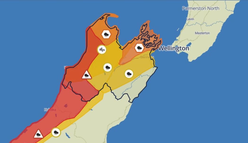
A portion of MetService’s weather watch page, which shows harsh weather for many parts of New Zealand this week, including multiple red and orange alerts.
Photo: Supplied/ MetService
Heavy rain warnings for Buller and Westland were upgraded to red-level warnings on Tuesday night, with rivers and streams expected to rise swiftly.
Red level warnings were only issued when extreme disruption was likely to occur, MetService said.
The forecaster said to expect significant flooding in Buller and Westland, with the potential for some communities to be cut off due to slips and floods that could make roads impassable, while river conditions were expected to become dangerous.
An orange alert remained in place for Nelson, Tasman, the Marlborough Sounds, Taranaki and Northland.
MetService said the weather was expected to move eastward across the country from Tuesday until Friday. It predicted a significant weather event, especially for places that had already experienced heavy rain recently.
Gale force winds were also expected, including for Northland, and the forecaster issued a reminder that warnings for other areas could be upgraded as the situation develops.
Buller Civil Defence controller Douglas Marshall said residents in low-lying areas should make their own evacuation plans and keep a bag packed with clothing and essential items.
The Buller Emergency Operations Centre had been activated and a community hub is in place at 175 Palmerston Street in Westport.
Buller Emergency Management said sandbags are available. It called for anyone who needs help preparing for flooding to ask – including help with sandbagging or welfare for themselves, their family or animals. The emergency management centre can be reached on 0800 768 348.
This heavy rain warning would be creating stress in the community, but support was available, a spokesperson said.
RED WARNING
In consultation with local councils, MetService has upgraded Rain Warnings for Buller and Westland to Red Rain Warnings. Red Warnings are reserved for only the most extreme weather events where significant impact and disruption is expected.https://t.co/qHyE5zzql5 pic.twitter.com/5wra58JI6X
— MetService (@MetService) August 16, 2022
A wave warning was also issued by the Buller Emergency Office for the West Coast, north of Cape Foulwind, where it said waves could reach heights of up to 5m.
The Insurance Council of New Zealand said anyone who does experience flooding should get in touch early. Lodging a claim early was the best way to ensure insurers could fix things quickly, they said.
Further north, in the Nelson and Tasman areas, Civil Defence was on standby.
Nelson City Council was urging residents to check drains and gutters were clear of leaves and debris.
A spokesperson said sandbags should be considered and properties near water, or in low-lying areas, should prepare for flooding.
Tasman District mayor Tim King said Civil Defence and roading crews were making preparations to go to Golden Bay where significant rain was forecast.
Heavy falls were also predicted for the Richmond and Bryant ranges and the Motueka Valley.
“If we get that very intense event in any of those locations it can have very severe ramifications. We’ve already had such a large amount of rainfall over the past eight to ten weeks, so the ground is already heavily saturated.”
Nelson Tasman emergency management public information manager Chris Choat said significant volumes of rain were predicted north of the Kahurangi National Park which would affect Golden Bay.
The rain had the potential to raise the levels of several rivers – the Aorere, Takaka, Moutere, Riwaka and Motueka.
It was likely to result in large floods, and the degree depended on the “bursts of intensity” of the rainfall.
He believed Wednesday would be the most significant day.
“We’re looking at [heavy] bursts … which can cause havoc. If it’s a constant stream we can handle it, but it’s those bursts that are going to cause havoc.
“That ground is already saturated … so any inundation of that level is going to cause some pretty severe surface flooding but at this stage we don’t know what level of impact there would be on houses.”
Choat said it was highly likely there would be slips in the Takaka Hill area and also the Whangamoas (the route to Blenheim).
Regional director for West Coast emergency management Claire Brown said there had been days of planning already.
It was likely that the upper Buller District would be worst affected, while there was also concern for the impact on South Westland.
With a second rain band due over the weekend, there was a lot of worry because “the area will be saturated by that time”, Brown said.
Waka Kotahi said there was a higher risk of tree falls, slips, and rockfalls in these regions as the rain continues in a very wet winter.
The Tasman District Council warned treated wastewater from the Motueka Wastewater Treatment Plant could seep into the nearby tidal estuary or the beach.
The council said it was over-pumping treated wastewater into a nearby soakage area as it prepared for the heavy rain. People were being asked to avoid the area and not to take shellfish from the estuary until further notice.
West coast residents brace for more flooding: ‘It’s pretty upsetting’
The predictions of heavy rain had West Coast residents anxious and frustrated, as more floods threatened for the hard-hit region.
After two major flooding events over the past year, it was a situation locals were all-too familiar with.
Rose Jackson has been back in her Westport home for only about four months, after being evacuated by Civil Defence in July 2021 as floodwaters inundated her property.

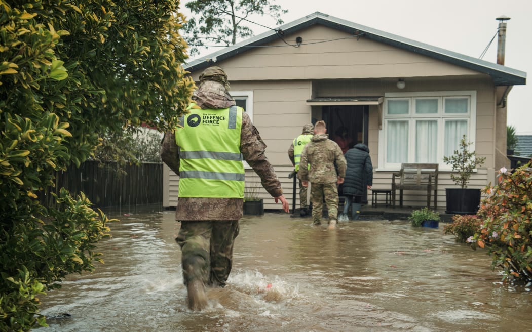
The Defence Force helped with evacuations in Buller in July 2021.
Photo: Supplied / NZ Defence Force
Jackson said it was hard not to feel anxious about the uncertainty in the days ahead.
“Apprehensive … is the word I would use,” she said.
“Not knowing what’s going to happen, it could turn very nasty or it could be a big event and not come to anything.
“It really depends on how much rainfall we get.”
MetService warnings warn up to 400mm of rain could fall in some parts of the West Coast, over the next two days.
Stephen Switalla has also just moved back into his newly repaired Westport home in April after copping flooding damage last year.
He said further weather warnings have left him feeling frustrated.
“We got through July and I thought we were okay,” he said.
“Now it’s the middle of August and we get this big rain warning again.
“It’s pretty upsetting when you hear it, especially with how much rainfall they’re predicting.”
Another Westport resident, Tania Hawken, told RNZ every weather warning was stressful and her anxiety was through the roof.
She said she spent yesterday lifting items in her garage onto higher surfaces after discovering during last year’s flood that her private insurer did not cover flood damage to garage contents.
Weather warnings are also in place further north in Tasman and Marlborough over the coming days.
Along the Kenepuru Sound, Ross Withell fears the road he lives on could sustain further damage after last year’s floods caused a major drop out.
“If this weather bomb comes through to anything like what’s forecast, there will be more damage, it’s just inevitable,” he said.
Local authorities at work preparing
Buller’s civil defence team has been organising sandbags, through Tuesday.
Buller mayor Jamie Cleine said the past 24 hours have been about getting ready.
“We’re just putting in the necessary steps and we’ve got some resource coming in from outside the district,” he said.
“It’s just a wee bit early to drill down exactly where and what resource will be required.
“The local volunteers are stepping up to assist with sandbagging and things like that.”
Cleine told Morning Report it has been a quiet night from Monday into Tuesday morning, so the expected downpour “was still in the pipeline”.
People have been brought in from outside the district to work in Civil Defence-type roles while deployable bunding and large pumps have also been procured so they were ready for use.
If the predicted rainfall eventuated there was potential for flooding in Westport and other parts of the district and the region also had a “fragile” roading system so surface flooding and slips were likely.
The land was already sodden and it would be “a tricky time” for motorists to be on the road.
There could also be significant snow melt because it was a warm northerly airflow that was delivering the wet weather.
A lot of snow could find its way into the rivers making the threat last into the coming weekend.
Cleine said with farmers in the middle of calving it was unfortunate that there was a possibility of flooded land.
“There’s a lot of anxiety and people are just over it; we we all are. But it’s mother nature isn’t it.”

Jamie Cleine says people in his region are over the rain and anxious about the next few days.
Photo: Buller Emergency Management
MetService meteorologist Lewis Ferris said there had been 5mm to 20mm of rain overnight from Monday to Tuesday. “That’s minute in comparison to what’s to come.”
“That rain has to go somewhere…”
Ferris said slips were “incredibly likely” around the Takaka Hill Road that takes traffic to and from Golden Bay.
An orange warning has also been issued for Mt Taranaki with up to 450 mm expected between Wednesday and Friday afternoons.
And an orange warning was issued for Northland on Tuesday night for northeast gales that could gust to 120kph, from Wednesday morning to Thursday night.
Other parts of the North Island were likely to be affected later in the week, Ferris said.
Steady rain developed overnight in Westland, 44mm at Franz Josef, 24mm at Hokitika so far, but there’s plenty more to come in the coming days. https://t.co/qHyE5zzql5 for full details ^DM pic.twitter.com/2Vn78c8XAK
— MetService (@MetService) August 15, 2022
Avalanche warnings
Warnings for very dangerous avalanche conditions are in place from some South Island alpine ranges.
The Avalanche Advisory has issued high danger alerts for Aoraki Mt Cook and Arthur’s Pass, and backcountry travel is not advised through to Thursday.
The advisory says a climber at Aoraki was swept along a naturally occurring avalanche yesterday but escaped uninjured.
Warnings for dangerous conditions are also in place for Ōhau, Wanaka and Mount Aspiring.


Discussion about this post