


One of North Carolina’s rarest weather events became a reality 15 years ago as a White Christmas unfolded across the state.
A two-part event on December 25 and 26, 2010, left snow falling in all 100 counties and more than a foot on the ground in parts of the Mountains and northern Coastal Plain.
With firsthand perspectives from two veteran forecasters at the National Weather Service in Raleigh, we’re telling the story of this storm, including the rarity of Christmas snow in North Carolina, the evolution from a vague forecast to a chaotic challenge to a snowy outcome, and the significance of this event 15 years later.
Our Brief History of White Christmases
Understanding what makes a White Christmas so rare is as much a lesson in luck as it is in meteorology. A previous analysis by our office found that December is tied with February as our least-active winter month for major snowstorms. It’s outpaced by January, when our normal temperatures are a few degrees cooler, and even by March, whose lion-like weather can include potent Nor’easters off our coastline.
In the years when we do see snow in December, getting it to line up with a single date – December 25 – is a roll of the dice that few gamblers would willingly take.
NOAA’s data gives much of the Piedmont, including Raleigh, around a 2% chance of seeing a White Christmas in any given year. That corresponds to about one White Christmas every 50 years, on average – or effectively a once-in-a-generation event.

We also see that reflected in the long gaps between recent occurrences of snow on or around Christmas. Before 2010, many areas saw an inch or two on December 23 in 1993, with similar amounts on Christmas Eve in 1966. But the previous case of snow falling on Christmas Day – the purest definition of a White Christmas – happened in 1947 in places like Raleigh and Rocky Mount.
Eastern areas had snow on the ground for Christmas in 1989 after a blizzard blanketed our Coastal Plain a few days earlier, but that storm, along with the 1993 event, had long been the only snows on record in Wilmington within a week of Christmas.
In the Mountains, where snow is more common, White Christmases are slightly easier to come by. But even Asheville sports only a 6% chance – a once-in-a-childhood sort of frequency – and snow on Christmas Day had only happened there twice in the previous 30 years: in 1981 and 1993.
With the probabilities stacked against us, White Christmases usually remain only in our dreams – or before 2010, in the most distant memories – for most folks from North Carolina.
Signs of Something Snowy
Entering the 2010-11 winter, there was little reason to believe that Christmas would be any different than most others. In fact, a fairly strong La Niña pattern, which tends to bring warmer weather and fewer storm systems in our region, threatened to make snow even less likely than usual.
But whether you call it a lucky break or a meteorological miracle, the start of that winter broke the typical La Niña pattern and beat the odds to produce wintry weather. With frigid air locked in during our state’s third-coldest December on record, the month began with two minor events.
On December 4 and 5, a clipper system dropped light snow across our northern counties, and a storm on December 15 and 16 brought a mixture of snow and ice in the same areas.
That slush had barely melted before another system appeared on the horizon. On Sunday, December 19, the forecast discussion from NWS Raleigh noted a threat of black ice that morning as cold weather continued – along with a potential storm the following weekend, which was depicted by both the American Global Forecast System (GFS) and the European Centre for Medium-Range Weather Forecasts’ (ECMWF) model.
Those model solutions were coarse and quite varied a full week out, and the discussion noted that “the only chance for snow would be for the upper trough to dig further south,” which would pull in more cold air while an offshore storm system pumped in Atlantic moisture.

Jonathan Blaes, the Meteorologist-in-Charge at NWS Raleigh, was working midnight shifts at the office that week, and he recalled how difficult it was to piece together the forecast using such limited data – with an analogy out of television history.
“It’s like back in the day when we had three network channels and five VHF channels, so you didn’t have that many options,” he said. “Back then, we had the GFS, the North American Model, the European, and that was kind of it. So you hung on those limited bits of data.”
That meant riding the ups and downs of each model throughout the week – and this event was an absolute roller coaster in terms of model performance, with big swings from one run to the next that’s best described by another vivid metaphor.
“I do remember the ‘windshield wiper effect’ in this one, and we often reference this storm to this date,” said Barrett Smith, then a second-year General Forecaster at NWS Raleigh and now the office’s Senior Service Hydrologist.
As Smith prepared to head north in December 2010 – not in search of snow, but to visit his and his soon-to-be-wife’s family in northern Virginia and Maryland over the holidays – his colleagues were left trying to untangle the oscillating model outcomes.

A Forecast Up in the Air
By December 21, the forecast discussion raised questions about the precipitation type: would we see rain, snow, or a mix? The following day, several scenarios emerged with light snow as the most likely. December 23 began with growing potential for a major snow event, but later trended toward a less significant winter storm.
All the while, public attention was increasing as snowflakes began to show up on forecasts for Christmas Day. Smith said snow forecasts typically bring scrutiny about possible school and business closings. That wouldn’t be an issue over the biggest holiday weekend of the year.
“This event had a lot of interest, but it was more of a news buzz, so it was kind of a different type of interest,” Smith said last week in reflecting on the December 2010 storm.
That buzz also included plenty of questions from family and friends, including for Blaes, whose in-laws were set to fly in on Christmas night – weather depending, of course.
“This was more of a personal, can-we-get-it-right kind of forecast challenge,” said Blaes.
And a challenge it certainly was. At the center of the uncertainty was how two waves of upper-level energy, initially thousands of miles apart to our north and west, would eventually come together over the Southeast US.
One wave would dive southward through a deep trough in the northern branch of the jet stream — the same feature that helped funnel in cold air in the days leading up to the storm. The other wave in the southern stream would race eastward across the Gulf coast.
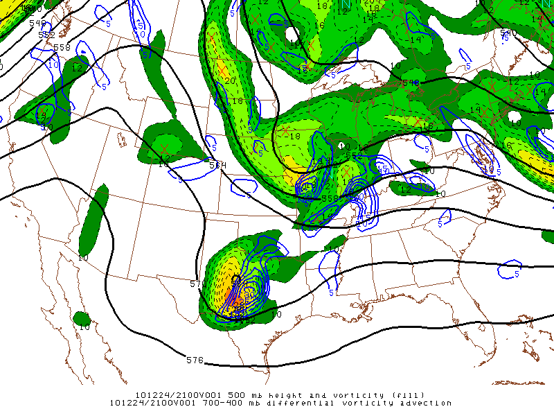
The timing of their interaction was key, as one wave arriving too early would form a weaker low farther inland, bringing less moisture and more warm air into our state. A delayed interaction would form the low farther offshore, keeping most of the precipitation to our east.
But a perfectly timed convergence, or phasing, of these jet stream shortwaves would be like lighting the fuse on a stick of dynamite, setting up the surface low pressure system for an equally explosive cyclogenesis right along our coastline — and supplying plenty of moisture into the cold air mass covering our state.
In this most classic winter storm setup for North Carolina, such an exact pattern is tough to nail down ahead of time since these waves are high above data-sparse areas such as the Pacific Ocean until just a few days before their rendezvous over our regional backyard, and small differences in where the low forms can have big impacts on moisture availability and temperature transitions.
During the December 2010 storm, another factor added to the complexity. On December 24, the Hydrometeorological Prediction Center – now the Weather Prediction Center – noted potential errors with data sampled from the northern shortwave over the Dakotas that may have contributed to that day’s snowier-looking model runs.
Faulty initial conditions could have made those results unreliable. As the saying goes: garbage in, garbage out.
Christmas Eve continued and confidence remained low, with some models steadfast about a snowier solution while others developed the surface low farther east, making for a cold but hardly snowy holiday in North Carolina.
Our Christmas weekend weather – and plenty of lifelong dreams – hung in the balance.
Statewide Snow in Two Acts
For snow lovers and weather enthusiasts, perhaps the best present they received in 2010 was the forecast clarity on Christmas morning.
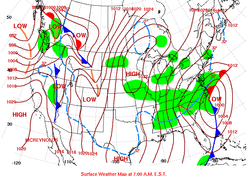
“Model guidance trends have swung almost 180 degrees from 24 hours ago, with [the] majority of the models shifting the track of the surface low closer to the coast with the surface low experiencing major deepening late tonight into Sunday morning,” noted NWS Raleigh’s 3:30 am discussion.
The result? “Potential for heavy snow totals along and east of the I-95 corridor late tonight through Sunday afternoon.”
It would take all day to refine the likely snowfall amounts – a Winter Storm Warning issued that afternoon called for 3 to 6 inches across the Piedmont, with locally higher amounts possible – and by then, a White Christmas had begun in earnest for parts of western North Carolina.
Ahead of the developing surface low, a batch of moisture arriving from the west fueled snow showers beginning that morning in the Mountains and just before noon in the Triad. That day’s snow totaled 6.5 inches in Asheville, 6 inches near Hickory, and 4.2 inches in Greensboro, on par with the forecast.

And there was more to come, especially for areas farther east once the main event began that night. The National Weather Service’s typically laid-back skeleton crew working on Christmas suddenly had their hands full as the chances of a big snow event increased.
“That dramatic shift occurred on Christmas Day, which meant we had to make a rapid adjustment to the forecast, and it was the holiday, so we did not have a lot of extra folks around to help,” said Blaes.
After the relief of knowing his in-laws had arrived safely, Blaes headed in for another midnight shift amid 16 consecutive hours of snow falling at the RDU Airport. By the next morning, the impact of that steady snow was apparent: 7.1 inches on the ground in Raleigh, and the most sizable snow there since January 2002.
Totals elsewhere in the Piedmont ranged from 2 inches in Charlotte to 5.5 inches in Sanford to 6.7 inches in Roxboro. There was an even wider range across the Coastal Plain, with a light dusting in Wilmington, 6 inches in Kinston, and a foot in Tarboro and Murfreesboro, along that Interstate 95 sweet spot that forecasters had previously identified.
Once the flakes had finished, Blaes returned home to his waiting family, weary from the frantic forecast but enchanted by the winter wonderland.
“The thing I remember most was the snow was so wet, it looked like melted marshmallows being drizzled on the bushes,” he said. “It was really, really pretty.”

A Landmark Storm
Winter wasn’t over after the Christmas storm in 2010. Just two weeks later, we saw a mostly light but widespread snow and ice event on January 10 and 11, while the Outer Banks picked up their biggest snow of the season on January 22.
Despite the snow, the expected dry weather in the 2010-11 winter finally set in by January, and February turned warmer as well, manifesting La Niña’s impacts later in the season.
The past 15 years have been plagued by plenty of wintry disappointment, including a nearly three-year snow drought between January 2022 and January 2025. Over that decade and a half, few – and in some areas, no – snowfalls have reached the same depths as in December 2010.
That Christmas storm remains the most recent 6-inch snow event for much of the interior Coastal Plain, including Fayetteville, Kinston, and Goldsboro, which saw 9.5 inches.
Raleigh’s 7.1-inch total has only been topped by one more recent storm: an 8.9-inch accumulation in December 2018. In Tarboro, the 12 inches on December 25 and 26, 2010, still stands as the biggest snow there in 25 years, dating back to early December of 2000.
Since 2010, Christmas snows have reassumed their historical rarity. The Mountains had snow on Christmas morning in 2020, but that event brought only a few flakes in other parts of the state. In Raleigh, half of all Christmases over the past 14 years never even dropped below freezing.

Reflecting on the fraught forecast for the 2010 storm, Blaes and Smith at NWS Raleigh highlighted how that event occurred at the beginning of a technological revolution that has changed weather forecasting for the better.
For one, what used to be a handful of models available to forecasters now numbers in the hundreds when counting individual ensemble members.
“Today, we have 100 members of this model system, 50 of that one. The extreme events are going to get captured. It’s just trying to understand what the probabilities are,” said Blaes. “That was the big problem back then, because we only had a few options, especially five and six days out.”
Those models have become more detailed, including the GFS shifting from a 27-km to 13-km global resolution in 2015. This helps them better predict elements such as convection – typically a warm-season feature associated with rising air and thunderstorms, but also a driver in heavy snow bands like the one that set up over Rocky Mount in the wee hours of December 26, 2010.
Smith added that the GOES-17 satellite, launched in 2018, has provided better data over the Pacific to help with monitoring atmospheric waves before they reach the US. The importance of tracking those features back in 2010 still stands out to him as a forecaster.

“That was one of the events that taught me about the evolution of those waves off to the west, and that you really had to understand how they would translate downstream and affect your forecast,” he said.
That event was also a showcase of several relatively new innovations in local observations. For one, the volunteer-based CoCoRaHS precipitation monitoring network launched in North Carolina in 2007, and more than 100 observers statewide reported their snowfall measurements during the Christmas 2010 storm, including some nearly 15-inch totals in Northampton County.
Our office’s ECONet weather station network, which was rapidly building out in 2010, has become a useful tool to assess the likelihood of snow sticking, as NWS Raleigh’s case study of the Christmas storm describes.
“Leading up to that event, it’s certainly something we kept an eye on, and the temperatures were favorable for accumulations,” said Blaes. “I remember looking at the map and they were in the upper 30s, lower 40s the day before. That’s plenty cold enough, and it means it’s not going to be a huge mitigator.”
That was one of many factors that lined up favorably to bring snow in a state where it’s always fickle – especially over our Christmas holiday historically.
But in December 2010, despite fluctuating forecasts that kept weather watchers on edge for a week, North Carolina became a marshmallow world in the winter with a once-in-a-generation White Christmas.


Discussion about this post