QUICK FACTS
Name: Salar de Uyuni
Location: Andean plateau, southwest Bolivia
Coordinates: -20.279074890164193, -67.35323215355417
Why it’s incredible: The salt flat is the largest on Earth and contains a huge chunk of the world’s lithium.
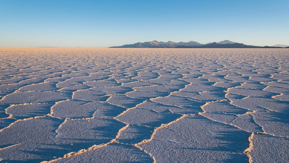
Salar de Uyuni is the largest salt desert on Earth, stretching roughly 4,000 square miles (10,400 square kilometers) across the Andean plateau. Uyuni is famous for its gleaming expanses of salt bathed in water, and for the mesmerizing honeycomb patterns found in the desert’s driest corners.
Salar de Uyuni has an average elevation of 12,000 feet (3,660 meters) above sea level — but it wasn’t always so. Around 5 million years ago, the region where the Andes mountains sit today was low-lying and the climate became arid, Sarah McKnight, an assistant professor of hydrogeology at the University of Dayton in Ohio, told Live Science.
Related: Andes region formed in 4 stages over the last 24 million years, new modeling study suggests
Over time, extreme heat and scarce rainfall caused prehistoric lakes in the region to evaporate, leaving behind crusts of sediment and salt. Tectonic processes and volcanic activity then pushed those crusts up onto a high plateau, where they remain to this day.
Compared with other salt flats like Salar de Atacama in Chile, which has a salt crust more than 3,300 feet (1,000 m) thick in some places, Salar de Uyuni is “pretty thin,” McKnight said, with a crust just 10 to 33 feet (3 to 10 m) thick. How much salt accumulates on a salt flat depends on the geology of the area, McKnight said, and the tectonic plates beneath Salar de Uyuni are much less active than those beneath Salar de Atacama.
Salar de Uyuni’s salt crust covers a layer of extremely salty water, or brine. But water also sits on top of the crust in some places due to a process called “freshwater upwelling,” McKnight said.
The salt flat is surrounded by snow-capped mountains and volcanoes that supply melt water to the rim of the crust. The freshwater slips beneath the crust but immediately separates from the brine due to the difference in salinity. “Since freshwater is less dense than the brine, it’s actually going to override or float, essentially, on top of the salt water,” McKnight said.
Freshwater upwelling is when freshwater migrates up through the crust and springs to the surface, creating lakes on the salt flat. Salar de Uyuni has between six and eight such lakes, which are vital for animals like flamingos that live in the desert, McKnight said. The size of the lakes varies depending on the season and on drought.
Freshwater trickling down from the surrounding peaks is the reason why Salar de Uyuni is one of the richest reserves of lithium on Earth, McKnight said. Hydrothermal and volcanic activity in the Andes means the mountains are rich in minerals including lithium, which water picks up as it flows over the rocks.
The salt flat sits in a mountainous region dubbed the “lithium triangle,” which includes parts of Bolivia, Argentina and Chile and holds 75% of the world’s lithium, according to the Harvard International Review.
Salar de Uyuni likely contains the lion’s share of the resource — 11.2 million tons (10.2 million metric tons), or about 38% of the world’s known lithium supplies, according to a 2012 study. (The U.S. Geological Survey estimates the salt flat contains around a quarter of the world’s supply, and the Harvard International Review quotes up to 50%.)
“What we think happens is [that] any inflowing water which has marginally elevated levels of lithium already from the hydrothermal and volcanic activity of the Andes gets concentrated more and more over time because of [evaporation],” McKnight said.
While resource exploration companies are interested in Salar de Uyuni, the lithium is so spread out along the salt flat that “we don’t have the available technology for extracting it in an economical way at the moment,” McKnight said.
And that’s good news for the salt flat, she said, because “these desert ecosystems are incredibly fragile.”


Discussion about this post