


It’s a climate conundrum: how can a year characterized by overall dry weather be most notable for its big precipitation events?
That’s the reality of 2025 in North Carolina, which featured persistent drought as well as the return of snowfall, welcome spring rains for agriculture, and a solitary soaking from the tropics.
As part of our annual year in review, we’ll cover more about statewide stats and rankings, storylines by season, notable hazards, our weather in a broader climate perspective, and features to watch in 2026.
The recording of our recent Year in Review Webinar, which covered much of the same content in this post, is also available.
Key Stats and Rankings
With an average temperature of 59.9°F, 2025 was our 22nd-warmest year on record since 1895 based on data from the National Centers for Environmental Information (NCEI). Each of the past 11 years in North Carolina has ranked among the top 25 warmest on record, including three of our state’s top five warmest years.
Locally, it was tied for the 5th-warmest year on record in Raleigh, the 7th-warmest year for Charlotte, and the 12th-warmest for both Asheville and Hickory. Coastal areas were less extreme, including a tie for the 25th-warmest year in Greenville and New Bern.
The year began with several weeks of wintry chill in January before warmer weather set in by February. A warm spring included our 2nd-warmest April on record, and the heat peaked with 100-degree temperatures in June and record warm nights in July.
August brought a sudden shift to cloudy and cool conditions, and that continued through a seasonable fall. The year ended with a December split between a cold start and a warm ending – including a record warm Christmas in some areas.
After a wet 2024, we flipped back to the dry side in 2025, which was our 25th-driest year on record out of the past 131 years, per NCEI, finishing 6.24 inches below the 30-year average.
That dryness was especially pronounced in the west, including the 5th-driest year on record in Jefferson and the 9th-driest year for both Statesville and Tryon. The few wetter-than-normal spots included central Piedmont areas soaked by Tropical Storm Chantal, such as Chapel Hill, which recorded its 14th-wettest year on record.
We started 2025 with our 7th-driest January and our 22nd-driest March, which helped drought persist into the spring. That lack of rainfall finally reversed in our 4th-wettest May on record, with wetter-than-normal conditions lasting through much of the summer.
By mid-August, dry weather returned and persisted into the fall, especially in our 16th-driest November that saw less than an inch of rain across parts of the state. Outside of coastal areas, December was dry as well, leading to a westward expansion of drought.

Big Stories by Season
Each season in 2025 saw shifting precipitation patterns and notable events, from falling snow to flooding rains to evolving drought conditions.
While last winter was dry overall with a weak La Niña pattern in place, it did see the long-awaited return of snowfall outside of the Mountains for the first time in almost three years.
In January, both the Piedmont and Coastal Plain had accumulating snowfall, while a mid-February event brought up to 8 inches in the northeast. Although the winter overall saw below-normal snow totals for many areas, it was better than nothing – which had been the result of the previous two winters.
The spring began with widespread drought carried over from the winter, but it quickly disappeared during a shower-soaked May featuring Asheville’s wettest day since Hurricane Helene and New Bern’s 3rd-wettest May on record. By early June, the state was finally drought-free for the first time in almost eight months.
Last spring was also notable for its warm temperatures, ranking as our 2nd-warmest spring on record statewide. That warmth was a wake-up call for pollen-producing vegetation, and the Division of Air Quality recorded its highest-ever grass pollen level in the month of March.

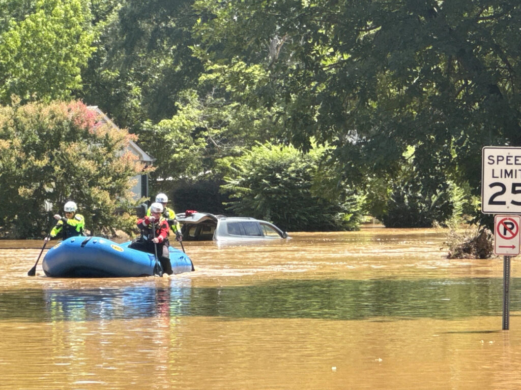
Our summer may best be described as soggy and steamy, as heavy rains continued, most notably when the remnants of Chantal crossed the state in early July. Parts of Alamance, Chatham, and Orange counties saw more than 8 inches of rain, which sent the Haw and Eno rivers rising to record levels.
After the storm, lingering humidity and a warm air mass in place led to a number of record-warm nights of July, including in Raleigh, which tied its all-time record warm low of 80°F. Statewide, July was our warmest month ever recorded based on the average low temperatures.
The fall featured typical temperatures but limited precipitation, ranking as our 16th-driest fall on record. From early September through mid-October, Snow Hill went 41 consecutive days with less than a quarter-inch of rainfall as Severe Drought emerged in eastern North Carolina.
Drought then spread westward during November, which was the 8th-driest on record in Charlotte, and following a dry December, we finished the year with drought affecting almost 60% of North Carolina.
Weather Hazards in 2025
Drought was almost inescapable in 2025. Per the US Drought Monitor, at least 20% of North Carolina was classified in drought during 33 out of 52 weeks in 2025 – the most since 36 such weeks in 2011.
For farmers, the winter drought meant small grains and pastures struggled, and despite the warm weather and an early last spring freeze in March, it was a slow and moisture-limited start to the growing season.
The May and June rain proved timely especially for the corn crop, which enjoyed a rebound year after being decimated by flash drought back in 2024. Despite the return of dry weather in August, the summer moisture reserves helped most crops reach the harvest in good shape.
The exceptions were some late-planted crops such as soybeans and cotton, which wilted and turned brown in the fall. And with drought expanding again entering this winter, farmers have faced similar struggles with stunted grains and pastures coming into 2026.

With such prevalent dry weather especially in the spring and fall, 2025 was an active year for wildfires. Preliminary data from the NC Forest Service lists 6,651 wildfires on state and private lands, which is the highest annual total in the past ten years. The total area of 35,817 acres burned ranks as third-most out of the past decade, but less than half of the 75,000+ acres burned in each of 2016 and 2023.
The five largest fires in the state last year all burned in the Mountains over a four-week period in March and April, including a pair of fires in Polk County that each burned more than 3,500 acres. Those large fires were made worse because of lingering storm damage from Hurricane Helene.
In the tropical Atlantic, Chantal proved to be the most impactful storm last year for North Carolina. Coastal areas also had a close call from Hurricane Erin in August, as well as from several October Nor’easters that caused overwash and collapsed homes along the Outer Banks.
Between the ongoing drought through the heart of our spring thunderstorm season and the lack of tropical activity affecting us in the fall, 2025 was a rather quiet year for severe weather in North Carolina.
Our 16 confirmed tornadoes were the fewest in a year since 2016, and we had no EF2 or stronger events for the first time since 2015. This was only the second time in the past 40 years – along with 2009 – that we finished a year without a confirmed tornado after August 15.

Perspectives on 2025
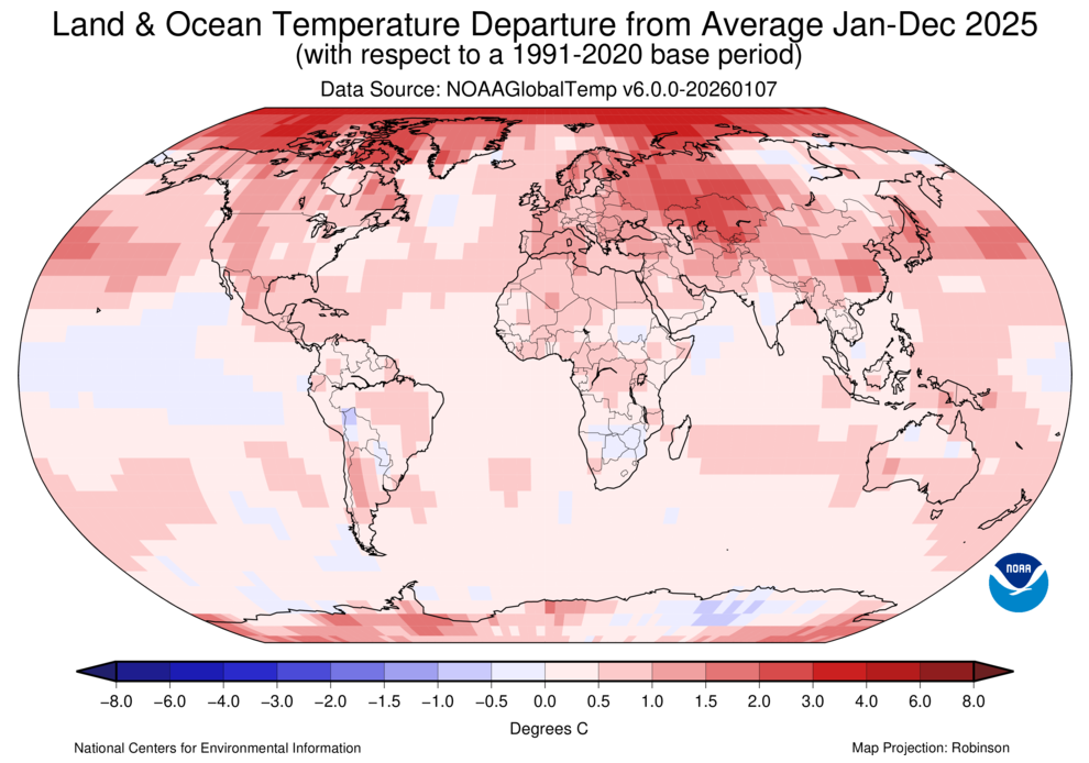
While North Carolina enjoyed overall milder temperatures in 2025 compared to other recent years, the same couldn’t be said globally. According to NASA, 2025 ranked as the 3rd-warmest year on record dating back to 1850, and the 11 warmest years globally have all happened in the past 11 years.
The oceans continued their streak of record warmth, setting a new record for the highest Ocean Heat Content for the ninth year in a row. This warmer water provides both energy and moisture to storm systems, including rapidly intensifying hurricanes such as Erin and Melissa.
Across the United States, conditions were generally warmer out west than in the east, and 2025 ranked as the 4th-warmest year on record nationally, per NCEI. Season-to-season and region-to-region temperature swings were also notable, including a cool January in many areas followed by a warm spring in the Southeast and a record warm November in parts of the central and western US.
Drought wasn’t just a concern in North Carolina. Nationally, 2025 was the 40th-driest year on record, 0.71 inches below the 20th-century average. At its peak this fall, drought affected more than 38% of the continental US, including much of the Southeast.
From a warmer ocean and atmosphere to stronger, wetter storms to flashier and more severe droughts, we know that climate change is driving many of the extremes being felt around the world, including in North Carolina.
We saw several notable examples of those changes in 2025. Chantal, as well as the slow-moving showers and thunderstorms following it this summer, brought extreme rainfall totals of more than 3 inches in the Piedmont – one of the regions identified by climate projections as the most likely to see such events in the future.
Those very warm summer nights when temperatures never dropped below 75°F are becoming more common as well, as the North Carolina Climate Science Report notes. Raleigh had 26 such nights last year, matching 2024 for the most on record there.
Storylines to Watch in 2026
At this time last winter, we were in the freezer and in between our two January snow events. While colder air has moved in over the past week and a few areas saw some flakes flying last Sunday, we’re still waiting for the first widespread snow event of this winter.
The next best chance could come as soon as this weekend. After cold air builds in on Friday, an offshore low pressure system developing on Saturday could bring a combination of snow, sleet, freezing rain, and rain across the state. As of Tuesday morning, the likelihood of impact is increasing for central and eastern North Carolina, and with cold air expected to stick around next week, anything frozen may be slow to disappear.
Beyond that, warmer weather is favored for February – and climatologically likely in La Niña winters, as we noted in our winter outlook.
With Severe Drought now covering more than half of the state, it’s also fair to wonder how long this drought will last. This is the fifth winter in a row with drought present in North Carolina, and in the previous four years, those droughts ended as early as February in 2023 and 2024, and as late as August in 2022.
A spring wet spell like we had last May could bring improvements relatively soon, but if the current dry pattern sticks around, then it could take longer to recover from this drought. On the extreme end, droughts in 2000-01, 2007-08, and 2011-12 took a year or more to fully go away.
Tropical storms are often one of our best bets for drought-relieving rainfall, but only if those storms come close – and they rarely did last year. In fact, there were no landfalling hurricanes in the US in 2025, and North Carolina hasn’t had a storm make landfall at hurricane strength since Isaias in 2020.
Thus, the anticipation is building for our next landfalling hurricane, while inland areas are also well aware of the dangers remnant storms can pose after the likes of Debby, Helene, and Chantal in the past two years.
Finally, after two years spent in a La Niña pattern, it appears we may shift into El Niño in 2026. That typically means a reduction in Atlantic hurricane activity due to enhanced upper-level wind shear, along with wetter weather in North Carolina’s cool season due to a southward-shifted storm track.
Current outlooks give about a 50% chance of El Niño emerging by the late summer, so it’s far from a guarantee, but certainly a pattern worth watching in the coming months.
Just as 2025 was a year of contrasts between the overall dry weather and a few snowy or stormy events mixed in, 2026 could be a year of transitions: away from La Niña, out of drought, and past the quarter pole of the 21st century.


Discussion about this post