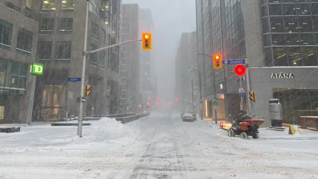
The winter storm hitting the Ottawa-Gatineau region has already broken a century-old record for snow for Jan. 17, and that snow coupled with the wind will make travel difficult for most of the day.
Winter storm and blizzard warnings continue to cover the entire region after light snow started off the storm early Monday morning in Ottawa, getting heavier after sunrise.
The snowfall is expected to continue through the day — with the worst in late morning — and falling until this evening, petering out some time after sunset in the capital.
About 12 centimetres fell in an hour at the Ottawa airport in the morning, according to CBC climatologist Ian Black. The 34 centimetres recorded there by 10 a.m. has already broken a one-day record for snowfall on this date, Jan. 17, in Ottawa using data back to 1873. The previous record was 22.9 centimetres in 1920.
Highway 7 has been closed between Highway 417 and Sharbot Lake because Ontario Provincial Police (OPP) say plows can’t keep it safe.
Eastbound Highway 417 is closed from Highland Road, or the exit to Maxville and St. Isidore, to County Road 23. Police are investigating a fatal crash between two large trucks and a passenger vehicle around 5:30 a.m.
By mid-morning, OPP in Ottawa said there were serious visibility problems on major highways and warned against taking them, saying they couldn’t guarantee help right away if drivers run into trouble.
TRAFFIC WARNING: <a href=”https://twitter.com/hashtag/OttawaOPP?src=hash&ref_src=twsrc%5Etfw”>#OttawaOPP</a> are advising all motorists to avoid travel on <a href=”https://twitter.com/hashtag/Hwy416?src=hash&ref_src=twsrc%5Etfw”>#Hwy416</a> & <a href=”https://twitter.com/hashtag/Hwy417?src=hash&ref_src=twsrc%5Etfw”>#Hwy417</a>, zero visibility. Cars will not be towed out of ditches if location is unsafe for emergency crews. STAY HOME! <a href=”https://twitter.com/511ONEastern?ref_src=twsrc%5Etfw”>@511ONEastern</a> <a href=”https://twitter.com/Ottawa_Traffic?ref_src=twsrc%5Etfw”>@Ottawa_Traffic</a> <a href=”https://twitter.com/OPP_COMM_ER?ref_src=twsrc%5Etfw”>@OPP_COMM_ER</a> ^jt <a href=”https://t.co/qCUhtKB1Lr”>pic.twitter.com/qCUhtKB1Lr</a>
—@OPP_ER
In Ottawa, the forecast called for anywhere from 20 to 30 centimetres of snow on Monday with wind gusts hitting 40 or 50 kilometres an hour. The high of –4 C is the warmest in a day in more than a week.

Further south
The Belleville area is another with widespread visibility problems and was the first to switch to a blizzard warning. Those problems are expected to improve, only slightly albeit, after 11 a.m. and will continue to present an issue until Monday evening.

Areas closer to the St. Lawrence River and Lake Ontario could see some morning ice pellets. A bit less snow could fall along Lake Ontario compared to the capital.
Kingston Transit has cancelled many routes today.
𝐒𝐞𝐫𝐯𝐢𝐜𝐞 𝐀𝐧𝐧𝐨𝐮𝐧𝐜𝐞𝐦𝐞𝐧𝐭: As of 10am, we will cancel all routes except for Express buses & Route 10. Routes will operate until end of trip and then go out of service. We will monitor winter conditions & may determine to reestablish local routes later today. <a href=”https://twitter.com/hashtag/YGK?src=hash&ref_src=twsrc%5Etfw”>#YGK</a>
—@KingstonTransit
To the capital’s north, Maniwaki’s forecast predicts 30 centimetres of snow.
There is the possibility that eastern Ontario communities could see 40 centimetres of snow, even 50 in some areas.
Latest modelling indicates 11-15 inches (~25-40cm) snow accumulation across much of the region today. <br>Also, Env Canada radar shows heavy snow along the St. Lawrence River inbound this morning. <br>It’s -10° now. W/c -20. High -4°. NNE winds 30-50 =blowing snow. <a href=”https://twitter.com/hashtag/ottnews?src=hash&ref_src=twsrc%5Etfw”>#ottnews</a> <a href=”https://twitter.com/hashtag/ONStorm?src=hash&ref_src=twsrc%5Etfw”>#ONStorm</a> <a href=”https://t.co/fk33c9Wwhi”>pic.twitter.com/fk33c9Wwhi</a>
—@BlacksWeather
The forecast has led to many cancellations, including all school buses for the region’s boards, and the closure of some community vaccine clinics.
Ottawa’s weather records don’t include many cases of 30 or more centimetres of snow in a single day — just 16 days since records were first kept.
Cold temperatures return Tuesday, resembling the weather that hit the capital last week, with a high of –16 C in Ottawa matching Monday’s overnight low. Wednesday could be warmer and bring more snow.


;Resize=(1180))


Discussion about this post