
A flood alert has been issued for Warkworth and forecasters have upgraded weather warnings for the upper North Island, as heavy rain is expected to sweep down from the north through into early Sunday, while strong wind watches and avalanche warnings are in place for parts of the South Island.
On Saturday, MetService upgraded earlier weather watches to orange Heavy Rain Warnings, for Northland, Auckland, Coromandel Peninsula, Bay of Plenty, and some parts of Tai Rāwhiti.
Up to 100mm could fall at rates up to 40mm an hour, though localised downpours could mean even higher amounts. The warnings were expected to be in place until 2am Sunday for Auckland, 3am for Coromandel, and 5am for Bay of Plenty and Tai Rāwhiti.
MetService warned people in all orange heavy rain warning areas to clear their drains and gutters, avoid low-lying areas and drive carefully. Waterways could rise rapidly.
A yellow heavy rain watch was also in place for Waikato.
Flood warning for Warkworth river, Aucklanders warned localised rain could be intense
Auckland Emergency Management (AEM) said a flood alert had been issued for Falls Road in Warkworth, on the Mahurangi River: “Please avoid taking Falls Road, particularly the sections where the road fords the river or that are typically affected by flooding”.
People in the Falls Road area of Warkworth should delay travel if they could, it said: “Stay safe – never drive through floodwaters”.
The Mahurangi River was already swollen by late Saturday afternoon, Auckland Emergency Management general manager Adam Maggs said, and there had been steady rain throughout the day.
Auckland’s Hisbiscus Coast Highway was closed between Hatfields Beach and Waiwera on Saturday night.
AEM said a slip had been reported, and an assessment was being carried out. A spokesperson says there were no signs of property damage, and traffic management was in place.
The forecast heavy rain in localised patches could mean flooding, Maggs said, and AEM teams would be keeping a close eye on the wider north and northwest parts of Auckland.
“It is very hard to determine where that is going to be. (MetService) are not expecting problems to be broad-scale across the whole region, so we have our contractors focusing on the areas that are typically the hot spots, and we have it well covered.”
There had only been a few call outs by late Saturday, which was typical of a rainy wintry day, Maggs said.
In Auckland, any blocked stormwater drainage should be reported to Auckland Council on 09 301 0101.
Avalanche risk and strong wind watches for South Island areas, continued storm mop up in Queenstown
In the South Island, yellow strong wind watches were issued for parts of Southland and Otago, along with some road snowfall warnings, while Queenstown continues its clean up efforts after it was hit by wild weather this week, causing flooding, slips and road closures.
Heavy flooding on Thursday, in Queenstown.
RNZ / Katie Todd
On Thursday night, 45 people were evacuated from their homes across the Queenstown Lakes District during the storm. And firefighters went to about 16 flooding-related jobs, in Queenstown, Frankton, Arrrowtown, Wānaka and Lake Hāwea.
Queenstown Mayor John Glover said he hopes residents will be able to return to their homes as soon as possible. He did not know how many people were still unable to return, but was expecting assessments would continue throughout the weekend.
The Civil Defence Welfare Hub at the Queenstown Memorial Centre was still open, Glover said.
On Saturday, the New Zealand Avalanche Advisory (which is run by the Mountain Safety Council) warned there was a high avalanche danger in mountainous areas throughout most of the South Island.
Warnings were issued for many areas, including Aoraki Mt Cook, Arthur’s Pass, Ohau, Queenstown, Wānaka, and Aspiring, with some noting varied risks for different places within those areas.

The Avalanche Advisory said the risk was especially high for Aoraki Mt Cook.
Unsplash / Corey Serravite
Aoraki Mt Cook, and parts of Queenstown were noted in particular.
Mountain Safety Council chief executive Mike Daisley said it had received reports of significant avalanches coming down to the valley floor: “This is not just a warning to alpine skiers and people heading into high alpine regions and backcountry.
“If people are considering going tramping into sub alpine regions you need to be aware of the hazards above you.”
People should check the avalanche forecast before heading into alpine backcountry, Daisley said.
In the North Island, Tongariro and Taranaki were also under considerable risk of avalanches as well.
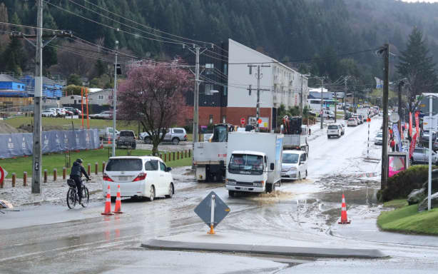
Roads were impacted in Queenstown’s CBD after the storm on Thursday.
RNZ / Katie Todd
Traffic congestion after road closures and slips
A number of road closures have also impacted the Queenstown region, which caused significant congestion in the town on Friday.
Fernhill and Sunshine Bay Community Association’s Simone Bray said restrictions at the one mile roundabout brought commuters to a standstill.
“We live on the top of a really big hill so there’s no active transport option for us either so we were sort of just advised if you don’t have to go anywhere just stay at home.
“The traffic was built up but it was taking people about an hour and a half basically just to go down the hill to get into Queenstown, which is normally a four minute drive.”
Residents in Fernhill, Sunshine Bay, Queenstown central and Frankton Road were also asked to conserve water.
There had been more than 20 slips, many of them substantial on the stretch between Lake Hāwea and Makarora.
Two cars and their occupants were freed after being trapped between slips on State Highway 6 near Wānaka on Friday.
The section of SH6 would remain closed all weekend, NZTA said.
Discussion about this post