
Periods of summer-like heat and limited rainfall combined to cause drought intensification last month, which has led to new emerging impacts across the state.
Untimely Temperatures
Several long stretches of unseasonable temperatures boosted this to one of our warmest Aprils on record. Based on preliminary data from the National Centers for Environmental Information (NCEI), last month’s statewide average temperature was 63.6°F, which ranks as our 2nd-warmest April since 1895.
That slotted in just ahead of last April, which also saw an early emergence of summer-like temperatures, and ranked behind only April 2017, which was warm but wet.
This April did finish as the warmest at a few stations. Both Hickory and Lincolnton recorded their warmest April dating back to the mid-20th century, while Greensboro tied 2017 for its warmest April on record.
Elsewhere, it was the 2nd-warmest April on record in Charlotte, the 3rd-warmest in Asheville and Raleigh, and the 5th-warmest for Fayetteville and Hatteras.
On the heels of our state’s 4th-warmest March on record, last month began with more 80-degree days – high temperatures more typical of early June than early April. Our weather pattern closely resembled the summer as well, with high pressure parked just off our coastline.
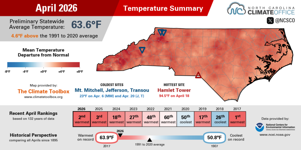
That warmth was briefly interrupted by crashing temperatures behind a cold front on April 8. The following morning, lows dropped below freezing in parts of the Piedmont. Raleigh’s low of 32°F on April 9 represented its latest spring freeze in five years, since April 23, 2021.
That chill was short-lived, though, as the return of high pressure across our region sent temperatures climbing well into the 90s by mid-month. On April 15, downtown Asheville hit 90°F, which was the first 90-degree day ever observed in April at that location.
On April 17, Marion logged its earliest 90-degree day since 2006, and our Sandhills ECONet stations in Hamlet and Lilesville each hit 94°F on April 18 in the warmest April readings on record at both sites.
By the end of the month, Raleigh had logged 12 days with temperatures at or above 85°F. That passed the 11 days last year for the most of any April. In Charlotte, the 10 days hitting 85°F or greater last month also set a new record for April, surpassing the 9 days that hot in 1925 – which, as we recently documented, was when one of our state’s worst droughts began to develop.

Dry Weather Dominates
Put simply, this April was bone dry across most of the state. Per NCEI, the preliminary statewide average precipitation was only 1.31 inches, ranking as our 5th-driest April in the past 132 years, and the driest since 1995.
In a month renowned for its showers, much of the Piedmont received less than an inch of rain in total this April. Greensboro had just 0.58 inches, Raleigh received 0.82 inches, and Charlotte managed 0.83 inches in the 5th-driest April on record at all three sites.
Wilmington also fell short of the one-inch mark with only 0.94 inches in its 20th-driest April on record. Other coastal areas fared slightly better thanks to rain showers during the final weekend of the month. However, even after almost two inches on a single Sunday, Newport still finished April with less than three inches in total, and a drier-than-normal month overall.
In between the light showers early and late in the month, sites including Charlotte, Raleigh, and Wilson each went 19 days in a row from April 6 to 24 with no measurable rainfall. That was Raleigh’s longest springtime rain-free stretch since May 2010.

Most of the Piedmont has now gone 48 days, or almost seven weeks, since their last half-inch rain event. That lack of significant rain since mid-March is a big reason why the statewide burn ban remains in effect.
Western areas ended April in slightly better shape after up to an inch of rain on April 28, but it was still an overall dry month in those areas. With 1.87 inches, Asheville had less than half of its normal rainfall in its 29th-driest April on record, and Murphy had only 2.43 inches in its 7th-driest April.
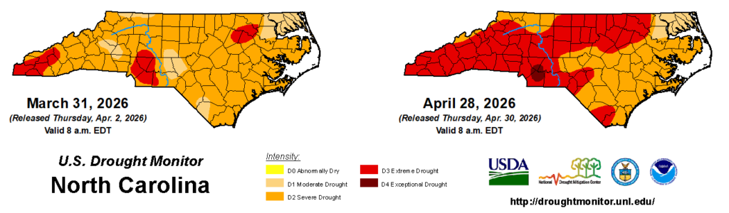
With such widespread dryness, almost 54% of North Carolina was in at least Extreme Drought (D3) and more than 95% was in at least Severe Drought (D2) by the end of the month. That remains the greatest coverage of those conditions since 2008.
A pocket of Exceptional Drought (D4) even emerged in the southern Piedmont, which has been the epicenter of dryness in recent months, with only 1.34 inches in Monroe since March 1 in its driest start to spring in the past 130 years.
Exploring More Drought Impacts
In our webinar and summary post a few weeks ago, we covered how this drought has affected water resources and fire danger. But there are plenty of other impacts to note that emphasize the severity and long-term nature of this drought event.
Groundwater levels began declining last fall, and after a lackluster recovery this winter, they’re trending down again already this spring. Since dropping below normal last October, the Grantham well (depicted below) in Wayne County struggled to improve over the cool season and saw a big drop-off in April as rain remained elusive.
Reservoirs have also felt the squeeze from limited incoming moisture and increased evaporation rates. In the Catawba-Wateree basin, Lake Norman ended April more than three feet below its normal target.
Those low levels, combined with other triggers such as streamflows, have pushed the basin into Stage 2 of its Low Inflow Protocol as of May 1, which has prompted mandatory water restrictions, including for Charlotte beginning on May 15.

Farmers have been feeling the effects of this drought since the fall, when some late-planted crops like soybeans and cotton missed out on rainfall late in the growing season. That caused their quality to decline or forced farmers to wait longer until harvesting.
The lack of wintertime precipitation left hayfields and pastures struggling, and the recent dryness has 64% of pastures in poor or very poor condition, per last week’s USDA/NASS report.
For livestock producers who may not have a sufficient hay crop to feed their animals, the onset of Severe Drought made them eligible for monthly payments via the Livestock Forage Disaster Program – one way the US Drought Monitor is used to inform drought relief.
Although soil moisture levels have been lacking, planting has continued roughly at the average pace, including for corn, soybeans, and tobacco. That makes the next few weeks even more critical for farms to receive some rain to help those crops germinate.

Even the northeastern corner of the state, which remains in only Moderate Drought (D1) thanks to more soaking rain events earlier this spring, hasn’t escaped the impacts of this drought.
Along the coastal interface between our freshwater rivers and saltwater sounds, droughts can push saltier water farther inland. One measure of that, the Coastal Salinity Index, has now reached the exceptional level on the Roanoke River near its junction with the Albemarle Sound.
The last time that stretch of the river was this salty for this long was in 2002 during another one of our state’s extreme and long-lasting drought events.
That salty water has had another unusual impact: last week, a Chowan County CoCoRaHS observer reported seeing porpoises swimming farther up the Sound than usual. Talk about an exceptional drought event!