
With an active hurricane season in full swing in 2011, a storm-free stretch along the North Carolina coastline abruptly ended amid the winds and waves of Hurricane Irene.
In some ways, the fifteen years since Irene feels like a lifetime given the spate of recent storms we’ve faced elsewhere, including inland flooding from the likes of Matthew, Florence, and Helene.
But for parts of the Outer Banks, Irene’s impacts are still apparent through our altered infrastructure and the future plans surrounding it as we seek to avoid a repeat of the events in August 2011.
For the first time on the Climate Blog, we’re remembering Hurricane Irene with a look at the storm and its impacts, including on a vulnerable section of our coast, the rapid response to get a key roadway reopened, plus how the state is preparing its infrastructure for what may happen down the road, and for the next big coastal storm.
Irene Makes Impact
After Hurricane Isabel battered the Outer Banks in September 2003, that region entered a relatively quiet era, even amid an overall active Atlantic basin. In 2004, the big storms went west and affected our Mountains, while 2005 saw only a glancing blow from Hurricane Ophelia, and 2010 had an even closer call from Hurricane Earl.
Despite that nearly eight-year absence of landfalling hurricanes at our coastline, it felt like our lucky streak was due to end. Outlooks for the 2011 season predicted above-normal activity due to a warm Atlantic and a lingering La Niña pattern, and eight storms developed within an eight-week period between late June and mid-August.
The next storm, Irene, formed on August 21 near the Leeward Islands and tracked toward the Bahamas, reaching Category-3 strength. Just four days out from North Carolina, the official forecast showed a potential landfall along our Crystal Coast as a major hurricane.
While an eyewall replacement cycle during its encounter with the Bahamas caused Irene to weaken, it remained a strong Category-1 hurricane as it headed due north toward North Carolina.
Local impacts began on Friday, August 26. As the outer rain bands overspread eastern North Carolina, a trio of tornadoes touched down in Beaufort, Tyrrell, and Washington counties.

The following morning around 7:30 am, Irene’s eye made landfall just west of Cape Lookout, holding at Category-1 intensity. Measured gusts were even stronger, reaching 115 mph at the Cedar Island Ferry Terminal, 92 mph at Ford Macon, and 88 mph at Cape Hatteras.
Thanks to Irene’s large size – tropical storm-force winds extended 225 miles from the center – it brought heavy rainfall over a broad area. Much of the central Coastal Plain received more than 12 inches, with the highest total of 15.74 inches in Bayboro. In Pamlico County, an estimated 25 to 30% of homes were flooded.
With many coastal areas entrenched in Extreme Drought, that rain was otherwise beneficial. However, the combination of high winds and wet ground toppled trees in New Bern, at East Carolina University, and through the roof of current state climatologist Jared Bowden’s family home in Rocky Mount. At the peak, there were 525,000 power outages statewide.
As Irene continued northward toward a secondary landfall in the Northeast US, the damage assessment began in eastern North Carolina, and it was clear that low-lying areas along the Pamlico Sound – which was whipped into whitecaps as the eye of the storm moved directly over – had suffered the greatest damage.
A seven-foot storm surge in Ocracoke affected more than 800 homes and businesses. Soundside communities across the Inner Banks region were inundated. And on Pea Island, the very character of the coastline was completely reshaped.

A New Chapter for New Inlet
The Outer Banks are famously fragile and constantly changing. Perhaps nowhere is a better example of that than Pea Island, which sits south of Oregon Inlet in eastern Dare County.
A report commissioned by the North Carolina Department of Transportation (NCDOT) traced the island’s history, particularly on its southern end, which has alternatively been connected with Hatteras Island and open to the ocean through the New Inlet.
The “new” in that name is relative, as it appeared on maps as far back as 1689, a century before North Carolina even became a state.
An open inlet there was historically beneficial, since it provided access to the Sound for both fish and fishermen. It was a relief, then, when a Nor’easter in 1932 reopened the inlet, and a hurricane in 1933 widened it.
The North Carolina State Highway and Public Works Commission – the predecessor of NCDOT – built the first bridge over New Inlet in the mid-1930s. But the inlet had largely closed by 1952, allowing NC Highway 12 to be paved as a surface road across Pea Island.

That basic lay of the land – with Pea Island connected to Hatteras Island – stayed the same for nearly 60 years. Then Irene arrived with its potent soundside storm surge and gouged a 200-foot-wide channel – which some media referred to as the “New New Inlet” – along with a narrower breach just north of Rodanthe.
Unlike in the past, an open inlet is a major inconvenience today due to its impact on land-based transportation, especially since Highway 12 is the only route on and off Hatteras Island. For modern-day engineers at NCDOT, this part of the coastline has become a hot spot for overwash and washouts, for multiple reasons.
“It’s at low elevation, the barrier islands shift and change and form, sand dunes come and go, there’s no protection of trees or other structures. It’s the elements, the geography, the landscape, and the weather,” said Andy Jordan, the State Hydraulics Design Engineer at NCDOT.
By 2011, Jordan was accustomed to storm response, typically with sizing replacements for washed-out bridges and pipes. But Irene presented a different challenge; “that was my first experience with breaches on the Outer Banks,” he recalled.
That kicked off a fast-paced response to reopen Highway 12 and prepare for the future of this road that spans our state’s shiftiest sands.

The Roadway Response
Immediately after Irene, emergency ferry service began across the Pamlico Sound between Rodanthe and the mainland at Stumpy Point, initially for emergency supply deliveries and recovery crews, then for nonresident homeowners by September 10.
The southerly breach near Rodanthe naturally filled back in, and the roadway was repaired. But for the New Inlet breach, the solution wasn’t as simple as dredging in sand, as was done with “Isabel Inlet” on Hatteras Island eight years prior.
Instead, officials opted for a fix straight out of 1935: building a bridge. While it was an old-school approach, it was done with longevity in mind for NCDOT.
“They were trying to step forward as far as resiliency, and they felt like in this area, the next storm most likely would open this back up again,” said Jay Twisdale, formerly the Assistant State Hydraulics Engineer and now a Project Manager at TGS Engineers, a private firm that still works closely with NCDOT.
By October 10, a temporary bridge had opened spanning the inlet. Built with a patchwork of metal plates that earned it the nickname “Lego Bridge”, it was quick to construct, but the clock was ticking on its effective lifespan.
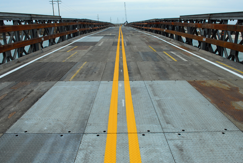
“It was all bolted together,” said Twisdale. “That’s a very corrosive environment, especially in an elevated structure like that, and being metal.”
That meant Twisdale’s group immediately set to work on designing a more permanent replacement.
After the completion of a wave vulnerability study in 2013, NCDOT drew up designs for a new bridge that spring. Construction began in March 2016 and was completed and opened to traffic in November 2017. It was later named the Richard Etheridge Bridge, after a former US Coast Guard captain who led the Pea Island Life-Saving Station.
The fluctuating nature of New Inlet was on display throughout this planning process. Hurricane Sandy in 2012 helped widen the inlet, but by the summer of 2013, it had naturally closed again. That has created an unusual scene for Outer Banks visitors crossing a bridge over no water.
“When you look at this bridge, people probably go ‘why is it even here; there’s sand on both sides of the road?’,” said Twisdale. “The wind and water have pushed the sand back in that opening, but it doesn’t take much for it to open back up.”
That sensitivity, as well as the intended 25-year lifespan of the Etheridge Bridge, means NCDOT is already planning for what the next iteration of Highway 12 near Pea Island could look like.

Feedback for the Future
Back in April, hundreds of residents, property owners, business owners, and visitors gathered to share their experiences with and expectations for the road that serves as the lifeline for Hatteras Island.
Those three public meetings, organized by NCDOT and the Federal Highway Administration, were part of the SAND Plan, a federally funded project seeking to identify the best pathway for long-term access along this tenuous part of the coastline.
“This is an 18-month grant, so we should have things wrapped up by next summer,” explained Lindsay Crocker, a Senior Project Manager with NCDOT. “Our goal is to have consensus on project purpose and need, and viable alternatives that we can bring into a future project.”
The initial input has confirmed the need for this sort of proactive planning. Out of more than 200 attendees at the first public meeting, two-thirds said they personally experience delays or closures three or more times per year on the Pea Island section of Highway 12 due to inclement weather and related events.
Among open-ended responses to an online survey, the top themes were reliable access and long-term solutions – or, as some put it, “stop spending money on sand movement.”

Crocker emphasized that the SAND Plan does not include funding for construction or preliminary engineering, but the preferred solutions could be streamlined for environment reviews and run through model simulations of storms like Irene, making it easier to implement them in the future.
A variety of options are being evaluated, and despite a contentious history in this part of the state due to costs, timelines, and environmental impacts, the public comments show an openness to a number of potential solutions.
In a summary of the first public meeting shared with the State Climate Office, 75% of respondents said they support long bridges across the Pamlico Sound, which could bypass Pea Island altogether, perhaps following the emergency ferry route between Rodanthe and the mainland.
And 76% support improving existing roadways, including using a series of bridges, like NCDOT has implemented in the past decade with the Marc Basnight Bridge over Oregon Inlet and the “Jug Handle” Bridge, which spans the flood-prone stretch north of Rodanthe that was breached by Irene.
Motivations certainly center on securing our transportation infrastructure, but in this key ecosystem, 53% of respondents said minimizing impacts on the Pea Island Wildlife Refuge and Cape Hatteras National Seashore habitats is moderately or very important.

Ready for the Next One
While it has been more than six years since the last direct hurricane landfall in North Carolina – Isaias in August 2020 – NCDOT has no concerns about being rusty whenever the next big hit happens at our coast.
“Even though our eastern divisions haven’t seen a hurricane recently, they’ve been very involved in the Helene recovery efforts,” said Jordan, whose current role at NCDOT focuses on design and preparedness. “Chantal came through the Piedmont not long ago, and that caused some washouts and flooding. And we’ve had some tropical storms here and there at the coast.”
Improvements in technology over the past fifteen years have also helped NCDOT anticipate and respond to hurricane impacts. Jordan noted acquiring new satellite radios to address communication challenges like they faced during Helene, as well as the advent of tools such as T-SAPP, which accurately forecasted inundation depths during another soundside surge event from Hurricane Dorian in 2019.
“Back during Irene and Isabel, there was no flood modeling. Now, we can see where surge is going to impact the coast based on the strength and the route a hurricane is going to take,” added Jordan.

On Pea Island, you’d never know it has been fifteen years since a hurricane hit. That flat, low-lying section of the coastline can experience overwash even on rainy days like we had in July, or during sunny-day, high-tide flooding events.
“Water is looking for the path of least resistance, and it found it here,” said Twisdale. “Most likely, it will find it again during the next hurricane. Let’s hope that’s a ways off.”
Ironically, in perhaps the most dynamic part of the state, where sands shift on a daily basis, Irene has left a permanent impact that continues to affect our movement through that region.
Water no longer flows through the New Inlet, but the bridge that spans it is a reminder of what happened fifteen years ago – and a sign of what the next storm could bring.
Discussion about this post