After almost three years of waiting, measurable snow fell again across parts of North Carolina late last week, ending long-running and, in some cases, record-setting snow-free streaks.
The setup for snow started taking shape more than a week earlier, when our first shot of chilly air this year arrived behind a cold front on January 3. A second frontal passage last Monday – which was preceded by a few snow showers on Sunday afternoon – kept our temperatures below normal all week, and high pressure to the north helped lock in the cold air at the surface, including soil temperatures in the 30s.
On Friday morning, a low-pressure system developed along the Gulf coast and eventually crossed our southern Coastal Plain that night, all while bringing in moisture from the Gulf of Mexico and the Atlantic Ocean.
It’s a familiar setup among North Carolina’s wintry events, albeit one we haven’t seen in several years amid our ongoing snow droughts. Most recently, a similar pattern with a storm developing to our south played out in December 2018 and January 2017.
Those events delivered higher snowfall amounts to the north and west, while this event had a comparatively broader transition zone, with more of the Piedmont seeing a switch to sleet and freezing rain by Friday night.
While the snow totals were generally light, the sight of falling flakes after two winters without any was welcome while it lasted.
Precipitation Summary
It was a relatively quick-hitting storm, with precipitation lasting 12 hours or less in most areas, but some spots in the Mountains and northern Piedmont still ended up with several inches of snow on the ground.
The highest snow accumulations reported by the National Weather Service were up to 7 inches around West Jefferson and 6 inches in Mount Airy, while the Cataloochee Ski Area in Haywood County reported 7 inches of new snow on Saturday morning.
Elsewhere in the west, the Grandfather Mountain Museum had 6.9 inches, Boone had 4 inches, and Asheville had 1.8 inches at the airport – the most snow there since January 16, 2022. That gave a snowy covering for parts of the city, and stretches of the Blue Ridge Parkway, still closed amid the ongoing recovery from Hurricane Helene less than four months after that storm.
Across the Piedmont, Greensboro had 2.1 inches of total snowfall in the third measurable snow of the season there. Yanceyville had 2.2 inches, Lincolnton had 1.2 inches, and Burlington measured an inch of snow on the ground.
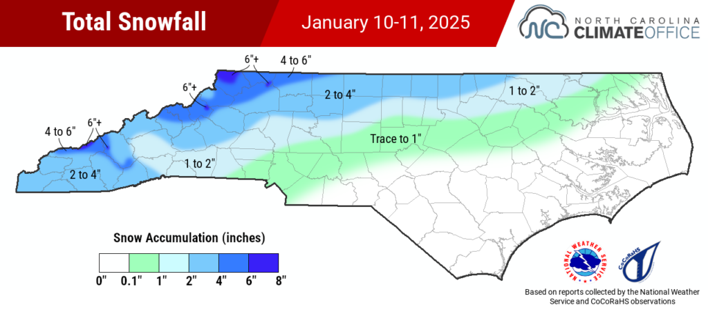
CoCoRaHS observations help fill in the local details, showing 3 to 5 inches in the Boone area, 1.5 to 3 inches across the Triad, and up to 1.5 inches in the Triangle. The Raleigh-Durham International Airport officially reported an 0.7-inch accumulation for the storm.
The snow ended early there, transitioning to sleet and eventually freezing rain with about a tenth of an inch of ice in Raleigh. Even greater freezing rain accumulations occurred in the Charlotte area, including a quarter-inch glaze in Gastonia and Indian Trail.
Despite the icy ending to the event across much of the Piedmont, less than 8,000 electrical customers were without power on Saturday morning.
Snow Droughts Expire
This long-awaited wintry event snapped snow-free streaks of more than 1,000 days across much of the state.
A few sites in the Foothills ended 1,084-day snowless streaks that began on January 22, 2022. In Marion and Shelby, it was their longest snow drought on record, while Morganton ended its second-longest snow drought dating back to 1894.
For parts of the Piedmont, snow-free streaks that traced back to January 29, 2022 finally snapped after 1,076 days. That was the case in Charlotte, which missed out on measurable snow in early December but totaled 0.5 inches from this storm. That also continued a trend of 6 of its last 8 snow events since 2019 having less than an inch in total.
Raleigh’s recent 1,076-day snow drought had been its second-longest on record, trailing only the 1,164-day snow-free streak ending in February 1993. A snowless winter this year would have eclipsed that mark, but this event reset Raleigh’s snow-free streak back to zero.
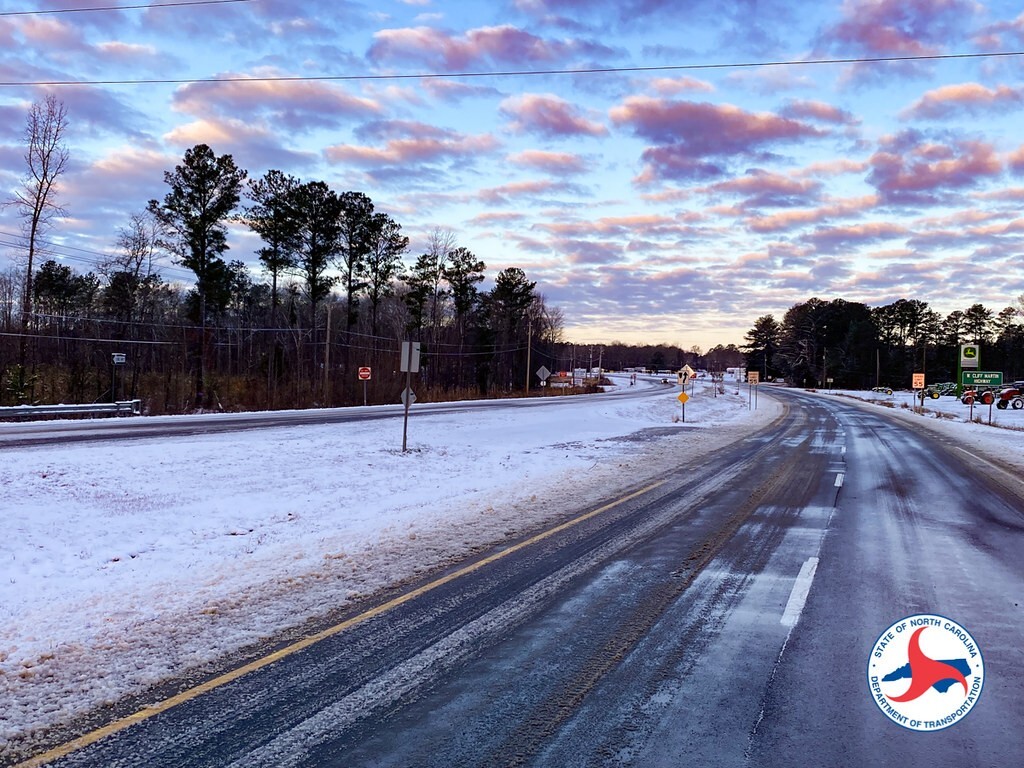
Parts of the far northern Coastal Plain saw snow, including 2 inches in Roanoke Rapids. But it was a mostly freezing rain or rain event to the south and east, which means snow-free streaks continue for areas such as Elizabeth City, still mired in its 2nd-longest snow drought on record.
For those areas and anyone else hungry for more snow after this short-lived event, our chances this season are dwindling as we cross the midway point of this climatological winter. The current 8- to 14-day outlook shows another cold air blast coming across much of the country next week, but recent longer-range model forecasts give a decidedly warmer look for February.
Even though the clock is ticking on our wintry potential for the season, we at least managed to fit in some flakes after a long wait.
Reminder: Our Year-in-Review Webinar is coming up! Join us on Tuesday, January 21 at 11 am ET for an overview of 2024’s weather and climate in North Carolina. Registration is free but required.




Discussion about this post