









Key Findings
- A Surprising Rift: Remarkably high fault scarps, reaching up to 400 feet, and a significant 6.5 magnitude earthquake in 2017 indicate that the Kalahari Craton in eastern Botswana—a cornerstone of geological stability in Africa—is undergoing tectonic separation.
- Reactivation of Ancient Faults: The current rift is utilizing a Jurassic-period fissure that had previously ceased activity, suggesting that the process of craton division may require multiple geological attempts.
- Fragmenting Microplates: Researchers propose that the San Plate, previously regarded as stable, may be in the process of dividing into two distinct plates.
In April 2017, a magnitude 6.5 earthquake originated from an unexpected location within the Kalahari Craton of eastern Botswana, an area characterized by its ancient crust, some of which dates back 3.7 billion years. Traditionally, geologists have viewed cratons as too rigid and stable to experience significant tectonic activity.
However, a recent study conducted by researchers from the Botswana International University of Science and Technology (BIUST) and the Lamont-Doherty Earth Observatory reveals that the Kalahari Craton is indeed undergoing tectonic expansion. The study, published in the journal Tectonics, challenges long-standing beliefs about continental stability and illustrates how ancient geological features can become active once more.
“The earthquake occurred in the heart of the craton, an area where we had not anticipated discovering active fault lines or developing plate boundaries,” stated co-author Folarin Kolawole, a structural geologist at Lamont and assistant professor in the Department of Earth and Environmental Sciences.
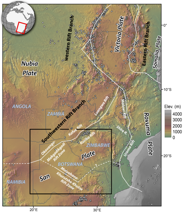
The newly identified rift represents the southernmost part of the East African Rift System, an area where the African continent is gradually stretching apart. Historically, scientists believed that the rift’s southern boundary was located within the Okavango Rift Zone of northern Botswana, identified in the 1970s by Lamont geologist Christopher Scholz and colleagues. However, investigations following the 2017 earthquake indicate that the rift extends nearly 200 miles further into the craton.
This revelation is unexpected, given that rifts typically circumvent cratons rather than traverse them. Worldwide, continental rifts are generally aligned with mountain chains, which are younger and structurally weaker zones formed by ancient cratonic collisions. Only a few known rifts, such as the one that created the Labrador Sea, have managed to penetrate a craton. “This finding is counterintuitive,” Kolawole remarks. “It fundamentally challenges entrenched geological assumptions.”
“The question of whether rifts can extend through cratons has long been a major topic in geoscience,” noted Boniface Kgosidintsi, the study’s lead author from BIUST.
The earthquake occurred in the heart of the craton, an area where we had not anticipated discovering active fault lines or developing plate boundaries.
Folarin Kolawole, Lamont-Doherty Earth Observatory
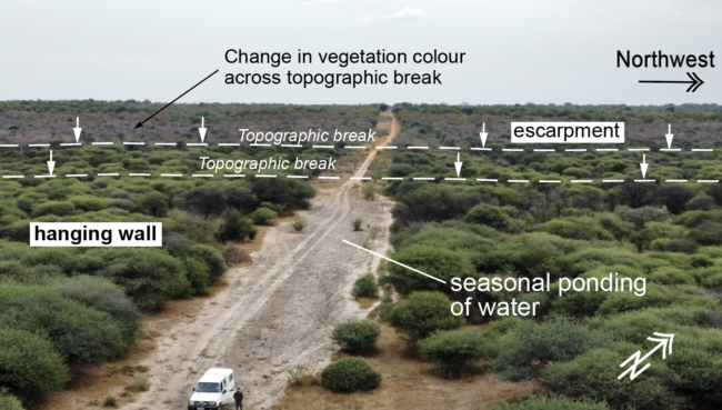
To analyze the rift’s interaction with the craton, the research team examined the Khurutshe Fault, which features a 50-mile-long scarp across the flat Kalahari landscape, located approximately 50 miles south of the 2017 earthquake. Some sections of the land adjacent to this fault rise as much as 400 feet higher than the other side.
The researchers conducted trenching across the scarp near Botswana’s A1 highway and investigated deeper excavations made for a governmental water pipeline. They employed electrical resistivity tomography to visualize the subsurface geology, likening it to a CAT scan of the fault, and analyzed data from 20 groundwater boreholes drilled in the vicinity.
All three methods produced consistent findings. When a fault slips, the land on one side subsides, leading to sediment accumulation in the depression, forming a wedge that thickens toward the fault. The analysis revealed that both contemporary Kalahari sand and older Jurassic rock layers formed these wedges, indicating that the fault was active during the Jurassic period, approximately 180 million years ago, and remains active today.
The trenches uncovered additional details about the fault’s historical activity. Beneath the reddish-brown Kalahari sand, the researchers discovered hard, highly-cemented Jurassic sandstone laced with calcite veins—resembling a spider web of white lines throughout the rock. This calcification was caused by hot fluids rising through fissures in the fault, similar to the processes that form mineral terraces in Yellowstone’s hot springs. Some rock surfaces exhibited polishing and scoring indicative of movement along the fault line.
The study concludes that the rift initially opened during a period of widespread continental stretching in the Jurassic, subsequently failed and went dormant until it was reactivated by the East African Rift System. Although the exact timing of this reawakening is uncertain, the fault has clearly displaced young Kalahari sands, which have accumulated mainly over the last 2.6 million years. “We believe the Khurutshe Fault is one of the dormant Mesozoic rifts within the craton that is now reactivating,” stated Kgosidintsi. The rift is still in its formative stages, but it is not a new phenomenon.
Weaknesses in Geological Structures
The researchers also determined that the faulting commenced prior to volcanic activity in the Jurassic, indicating that magma alone did not sufficiently weaken the craton to initiate the rift. Instead, the rift capitalized on pre-existing weaknesses. The active rifts in eastern Botswana follow an ancient seam where the oldest components of the Kalahari Craton fused billions of years ago.
“Although cratons are often viewed as robust and stable continental blocks, they possess inherent zones of weakness that can facilitate the emergence of new plate boundaries,” Kolawole explained. He added that successfully breaking apart a craton might require persistence: “It may take multiple reactivations for the rift to ultimately succeed.”
These findings also have significant implications for the tectonic mapping of southern Africa. Some researchers have suggested that the area south of the Okavango Rift constitutes a single, stable microplate known as the San Plate. However, the presence of an active rift producing large earthquakes and fresh fault scarps within this region raises questions about the coherence of this plate. “We cannot assume that the plate is undivided,” Kolawole stated, suggesting instead that the San Plate may be gradually dividing into two smaller plates: the North San Plate and the South San Plate.
Any potential fragmentation will occur over millions of years, if at all. Current GPS data indicates that rifts in southern Africa are opening at a significantly slower pace compared to more developed rift segments in Malawi, Kenya, and Ethiopia. Such gradual rifts may stall and ultimately fail. Nonetheless, Kolawole observed that plate boundaries “often begin slowly before accelerating later in their lifecycle.” This study provides a rare opportunity to observe the early stages of plate boundary formation and offers insights into Africa’s eventual geological evolution. “These systems represent fractures that may eventually dictate the formation of a new ocean,” he remarked.
The study’s additional authors include Bokani Nthaba and Elisha Shemang from BIUST, alongside Zachary Foster-Baril from Lamont. The research received funding from the Columbia Climate School, the G. Unger Vetlesen Foundation, and the National Geographic Society.







Discussion about this post