
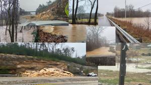
The National Weather Service in Paducah has issued a

* Flash Flood Warning for...
Southeastern Ballard County in western Kentucky...
Calloway County in western Kentucky...
Carlisle County in western Kentucky...
Fulton County in western Kentucky...
Graves County in western Kentucky...
Hickman County in western Kentucky...
Southern Livingston County in western Kentucky...
Southern McCracken County in western Kentucky...
Marshall County in western Kentucky...
Southeastern Mississippi County in southeastern Missouri...
Southeastern New Madrid County in southeastern Missouri...

* Until 200 AM CST Sunday.

* At 536 PM CST, Doppler radar indicated thunderstorms producing
heavy rain spreading back into the warned area. The rain that
falls this evening will be on top of heavy rain that has already
caused widespread flooding earlier today. Numerous roads are
either closed or impassable, and that is only expected to worsen
through the evening. Between 2 and 5 inches of rain has already
fallen. Additional rainfall amounts of 1 to 3 inches are expected
in the warned area. Flash flooding is already occurring and is
expected to intensify. Significant flash flooding is likely.

HAZARD...Life threatening flash flooding. Thunderstorms
producing flash flooding.

SOURCE...Emergency management reported.

IMPACT...Life threatening flash flooding of creeks and streams,
urban areas, highways, streets and underpasses.

* Some locations that will experience flash flooding include...
Murray, Mayfield, Benton, Portageville, East Prairie, New Madrid,
Calvert City, Fulton, Hickman, Clinton, Lilbourn, Bardwell,
Wickliffe, Reidland, Towosahgy State Historic Site, Big Oak Tree
State Park, Hunter-Dawson State Historic Site and Marston.

PRECAUTIONARY/PREPAREDNESS ACTIONS...

Turn around, don't drown when encountering flooded roads. Most flood
deaths occur in vehicles.

Be especially cautious at night when it is harder to recognize the
dangers of flooding.

Please report observed flooding to local emergency services or law
enforcement and request they pass this information to the National
Weather Service when you can do so safely.

&&


FLASH FLOOD...OBSERVED;
FLASH FLOOD DAMAGE THREAT...CONSIDERABLE
.Showers and thunderstorms will continue into tonight. Radar
estimates of 1 to 4 inches of rain has already fallen across the
watch area. Showers and thunderstorms this afternoon and into
tonight will bring another 1-3 inches of rain. This may be a major,
potentially historic, flash flood event.

...FLOOD WATCH REMAINS IN EFFECT THROUGH LATE TONIGHT...

* WHAT...Significant and widespread flash flooding caused by
excessive rainfall continues to be possible. This is a
particularly dangerous situation.

* WHERE...Portions of southern Illinois, including the following
areas, Hardin, Massac and Pope, southwest Indiana, including the
following area, Spencer, western Kentucky, including the following
areas, Ballard, Caldwell, Calloway, Carlisle, Christian,
Crittenden, Daviess, Fulton, Graves, Henderson, Hickman, Hopkins,
Livingston, Lyon, Marshall, McCracken, McLean, Muhlenberg, Todd,
Trigg, Union KY and Webster, and southeast Missouri, including the
following areas, Mississippi and New Madrid.

* WHEN...Through late tonight.

* IMPACTS...Excessive runoff may result in flooding of rivers,
creeks, streams, and other low-lying and flood-prone locations.
Storm drains and ditches may become clogged with debris. Extensive
street flooding and flooding of creeks and rivers are possible.

* ADDITIONAL DETAILS...
- With 1 to 4 inches of rain already fallen and an additional 1
to 3 inches of rain expected, significant and widespread
flash flooding is still expected if not already occurring.


PRECAUTIONARY/PREPAREDNESS ACTIONS...

Those in the watch area should take precautions for flood
conditions. Remove debris from storm drains and clear flood prone
locations. You should monitor later forecasts and be prepared to
take action should Flash Flood Warnings be issued.

&&
The National Weather Service in Paducah has issued a

* Flash Flood Warning for...
Massac County in southern Illinois...
Southern Pope County in southern Illinois...
Ballard County in western Kentucky...
Livingston County in western Kentucky...
McCracken County in western Kentucky...

* Until 745 PM CST Saturday.

* At 140 PM CST, Doppler radar and automated rain gauges indicated
heavy rain falling across the warned area. Between 1 and 2 inches
of rain have fallen. Additional rainfall amounts of 1 to 3 inches
are possible in the warned area. Flash flooding is ongoing or
expected to begin shortly.

HAZARD...Flash flooding caused by heavy rain.

SOURCE...Radar and automated gauges.

IMPACT...Flash flooding of small creeks and streams, urban
areas, highways, streets and underpasses as well as
other poor drainage and low-lying areas.

* Some locations that will experience flash flooding include...
Paducah, Metropolis, Calvert City, La Center, Wickliffe, Lone Oak,
Reidland, Brookport, Salem, Barlow, West Paducah, Barkley Regional
Airport, New Columbia, Ledbetter, Lovelaceville, Burna, Kevil,
Joppa, Olmsted and Smithland.

PRECAUTIONARY/PREPAREDNESS ACTIONS...

Turn around, don't drown when encountering flooded roads. Most flood
deaths occur in vehicles.

Be aware of your surroundings and do not drive on flooded roads.

&&


FLASH FLOOD...RADAR AND GAUGE INDICATED
...The National Weather Service in Paducah KY has issued a Flood
Warning for the following rivers in Kentucky...Illinois...Missouri...
Indiana...

Ohio River at Paducah affecting Livingston, McCracken, Massac and
Pope Counties.

Ohio River at Cairo affecting Alexander, Mississippi, Ballard,
Hickman, Fulton, Carlisle and Pulaski Counties.

Ohio River near Henderson affecting Posey, Henderson and
Vanderburgh Counties.

Ohio River at Owensboro affecting Spencer and Daviess Counties.

Ohio River at Evansville affecting Daviess, Posey, Vanderburgh,
Henderson and Warrick Counties.

Ohio River at Golconda affecting Hardin, Livingston, Crittenden
and Pope Counties.

.Very heavy rainfall is falling across the Ohio Valley. Parts of the
river are already experiencing high water and runoff from today's
rain will lead to another crest later in the month.

PRECAUTIONARY/PREPAREDNESS ACTIONS...

Turn around, don't drown when encountering flooded roads. Most flood
deaths occur in vehicles.

Additional information is available at www.weather.gov.

&&

...FLOOD WARNING IN EFFECT FROM SUNDAY EVENING UNTIL FURTHER
NOTICE...

* WHAT...Minor flooding is forecast.

* WHERE...Ohio River at Paducah.

* WHEN...From Sunday evening until further notice.

* IMPACTS...At 39.0 feet, Minor flooding occurs affecting mainly
bottomland and surrounding low lying areas.

* ADDITIONAL DETAILS...
- At 11:00 AM CST Saturday the stage was 36.6 feet.
- Forecast...The river is expected to rise above flood stage
tomorrow evening and continue rising to a crest of 40.5 feet
early Tuesday afternoon.
- Flood stage is 39.0 feet.
- http://www.weather.gov/safety/flood

&&