
This August featured several weeks of heat, plus a mix of heavy rain and dryness. That capped off a hot summer that saw the first signs of drought recovery.
More Sizzling Summer Days
Fueled by a long stretch of mid-month heat, this was one of the top five warmest Augusts on record in North Carolina. Per the National Centers for Environmental Information (NCEI), the preliminary statewide average temperature of 78.6°F ranks as our 4th-warmest August since 1895.
It was also a top-five warmest August at many long-term weather stations. New Bern tied for its 3rd-warmest August on record, Raleigh had its 4th-warmest August, Fayetteville tied for its 4th-warmest, and Lumberton had its 5th-warmest August.
The main weather pattern at play last month was a broad area of high pressure over the Southeast US. From August 6 and August 20, Fayetteville had highs of 90°F or greater on 15 consecutive days, including 100°F readings on August 17 and 20, and 98°F on August 18 to tie its daily record high.
During that same stretch, Lumberton peaked at 102°F on August 17 in its hottest day of the year so far, Elizabethtown hit 104°F that afternoon in its hottest day since August 2007, and Goldsboro reached at least 100°F four days in a row in its longest such streak since July 1998.
A cold frontal passage on August 21 ushered in more seasonable temperatures for the final week of the month, but that still included another string of days in the low 90s for parts of eastern North Carolina.
Laurinburg finished the month with 24 total 90-degree days, which was tied for the 10th-most of any August on record there. And Elizabeth City hit the 90-degree mark on 15 days last month, which was its most in August since 2021.
August often delivers our first feeling of fall, like it did in 2025, but that wasn’t the case this year. Greensboro averages its first night in the 50s on August 23, but its coolest low temperature last month was only 61°F on August 25. Each year between 2019 and 2023, the Triad had to wait until September for that first crisp night of the season.

Mixed Rainfall, Minimal Drought Changes
A few wet areas were outweighed by larger dry patches, leaving the state slightly drier than normal overall last month. NCEI notes a preliminary statewide average precipitation of 4.41 inches and our 47th-driest August out of the past 132 years.
While the rain wasn’t as widespread as in July, August still brought locally heavy showers and thunderstorms that left some spots much wetter than normal, especially in southeastern North Carolina.
Most notably, Wilmington finished the month with 15.01 inches of rain in its 2nd-wettest August on record. That impressive rainfall haul came without any contributions from tropical systems. Much of it fell along a stalled frontal boundary from August 20 to 22, which brought a maximum daily total of 5.31 inches.
In addition, we saw plenty of pop-up thunderstorms along our coastline, including one that spawned a brief tornado in Carteret County on August 24.
Another round of slow-moving showers on August 27 brought local totals of almost seven inches in Cumberland and Scotland counties, which caused a brief rise to flood action stage on Leith Creek in Laurinburg.

It was also a wet month in the Foothills, with Marion reporting its 18th-wettest August on record and Forest City tallying 10.77 inches in its 2nd-wettest August out of the past 22 years.
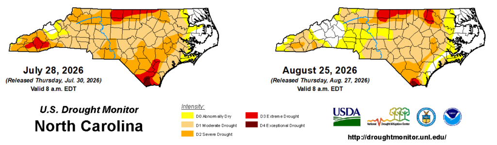
Those wet areas saw further drought improvements, including the southwestern Piedmont shifting back to the Abnormally Dry (D0) level while parts of our southern coastline are now unclassified on the US Drought Monitor thanks to the recent heavy rain and an alleviation of impacts.
Conditions were much drier across our northern tier, including just 0.88 inches in Louisburg in its 6th-driest August on record and 1.03 inches in Roanoke Rapids in its 5th-driest August. Reidsville recorded another dry month, with 1.23 inches in its 3rd-driest August since 1962, and fresh off a soaking July, Raleigh had only 1.21 inches in its 7th-driest August on record.
Those northern areas remain in Extreme Drought (D3), and as lake and streamflow levels in the upper Roanoke River basin continued to decline, a new area of D3 emerged in parts of Warren and Halifax counties.
A Hot Summer, in Review
Even if the weather this week may beg to differ – with forecasted highs in the triple digits again on Friday – August officially marked the end of the climatological summer.
Hot weather was indeed a big part of the season, and it shows in the final rankings. Based on the preliminary data from NCEI, the average temperature of 77.8°F ranked as the 5th-warmest summer in North Carolina since 1895.
Locally, it was the 3rd-warmest summer on record in Wilmington, trailing only 2010 and 2011. Raleigh and Fayetteville each had their 4th-warmest summer, and it was tied for the 5th-warmest in Charlotte and Greensboro.
Heat dome patterns in early to mid June and early July brought extreme temperatures in parts of the state. Fayetteville finished the season with 10 total 100-degree days, which is tied for the 3rd-most in any summer there out of the past 111 years.
By one measure of heat stress, the Wet Bulb Globe Temperature, eight of our 46 ECONet stations recorded more than 200 hours at the High Risk level this summer. That included 127 hours in the Extreme range on Bald Head Island – its most in a single year – with a maximum WBGT of 94°F on July 21 at 1 pm.
Dating back to the spring, when our first hot days began in March and continued in April, Wilmington has had 59 days this year hit at least 90°F. That’s the 2nd-most all-time there through the end of August, behind only 2019. Greensboro, Raleigh, and Fayetteville have also had an above-average number of 90-degree days so far this year.

NCEI’s preliminary data also shows that this summer was our 46th-driest out of the past 132 years, with a statewide average precipitation of 14.06 inches, or one inch below normal. Most areas finished within four inches of their normal rainfall, ranging from the 26th-wettest summer on record in Asheville to the 22nd-driest in Greensboro.
After the hot start to June, more than 45% of the state was in Extreme Drought (D3) or worse, including parts of the northern Piedmont at the Exceptional Drought (D4) level. The more frequent rainfall that followed, especially during July’s multi-day rain event, brought widespread improvements, leaving less than 5% of the state in Extreme or Exceptional Drought by the end of summer.
As we begin the climatological fall, two big questions linger: how long will the heat last, and when will El Niño’s local impacts begin?
The latest Week 3 to 4 outlook from the Climate Prediction Center favors above-normal temperatures across the southern tier of the US through late September. For reference, the average last 90-degree day in Raleigh is on September 12, but it has occurred as late as September 25 last year and in early October from 2017 to 2019.
As for El Niño, it continues to have an impact on the tropical Atlantic, with strong wind shear over the Caribbean. While a few short-lived storms formed last week in Dolly and Edouard, the expectation remains for below-average activity in the Atlantic this year.
The usual cool-season jet stream impacts associated with El Niño, which tend to bring wetter weather in our part of the country, haven’t begun yet, but some longer-range forecasts show that pattern setting up by October.
That means this fall will be a decisive season in determining whether drought degrades again amid our September heat, or continues to improve once El Niño takes control.
Discussion about this post