
After hundred-degree temperatures early on, July ended with soaking rainfall that has improved, but not eliminated, drought conditions across the state.
A Warm Month With a Sizzling Start
Despite a late-month cooldown, our early heat waves cemented this as an overall warm July in North Carolina. The National Centers for Environmental Information (NCEI) reports a preliminary statewide average temperature of 79.3°F and our 10th-warmest July since 1895.
Locally, it was tied for the 5th-warmest July in Charlotte, the 7th-warmest July in Wilmington, and tied for the 9th-warmest in Cullowhee. Elsewhere, Asheville tied for its 12th-warmest July, Greensboro tied for its 13th-warmest, and Raleigh tied for its 18th-warmest July on record.
The first three weeks of the month featured multiple periods of extreme heat, beginning with a “heat dome” pattern – with a broad area of upper-level high pressure over our region – leading up to the Independence Day weekend.
Beginning on July 1, temperatures surpassed 100°F as far west as Morganton, which recorded three total 100-degree days last month – its most in any month since July 1993. The heat spread eastward from there, including Greensboro‘s first 100-degree day since 2012 on July 2.
The mercury reached 103°F on July 3 at our Salisbury and Lilesville ECONet stations, and on July 4 at our Durham station and the Raleigh-Durham Airport, which had its hottest Independence Day on record.
It was also a record-hot holiday for sites such as Roanoke Rapids (102°F), Shelby (101°F), Fayetteville (100°F) and Greenville (100°F). Likewise, Lillington set a new daily record high of 102°F, which was part of four consecutive 100-degree days there, matching its longest streak on record from July 2012.
The next surface high pressure system over the Southeast US produced another round of extreme heat by July 8, including a high of 102°F in Wilmington on its hottest day since 2012. And high pressure over the Deep South fueled triple-digit temperatures again on July 18, including in Snow Hill, which has now recorded three 100-degree days so far in 2026 after none in 2024 or 2025.
That heat finally backed off as a cold frontal passage on July 22 ushered in some cloudy, wet, and unseasonably cool weather. On July 23, Raleigh only reached 74°F to break its daily record cool high temperature, and Greensboro tied its daily record with a high of only 73°F.
Those cool days are nice, but heat is a mainstay in our summer climate. If you work for a local government and you want to prepare your community for future heat waves like we experienced in July, consider applying for North Carolina’s Planning for Extreme Heat Cohort.
This program connects city, county, and emergency management officials with a network of experts, a wealth of resources, and the guidance needed to draft heat action plans tailored to local needs and capabilities.
The Cohort is a free service offered by the State Resilience Office and the State Climate Office. To learn more, see this flier, read past participant testimonials, and register for an informational webinar on Monday, September 14 from noon to 1 pm. Cohort applications are due by Friday, September 25.

Showers and Storms Soak the State
In a reversal of our recent dry pattern, many areas had ample rainfall as part of an overall wetter-than-normal July in North Carolina. Per NCEI, the preliminary statewide average precipitation was 6.73 inches, which ranks as our 30th-wettest July out of the past 132 years.
July’s rain represents a remarkable turnaround from where we’d been since last fall, when drought first took hold. Most impressively, Raleigh had more rain last month – 12.16 inches in its 2nd-wettest July on record – than it had seen over the first six months of the year combined.
Other parts of the state also tallied more than ten inches of rain last month. In Celo, the 13.29 inches ranks as its 3rd-wettest July since 1948. Concord had 12.35 inches and its 3rd-wettest July. And Plymouth finished with 10.79 inches and its 9th-wettest July on record.
The rain accumulated during multiple events, beginning with scattered but locally heavy showers after the Independence Day weekend. On July 7, Oxford had 2.90 inches, and on July 8, Murfreesboro picked up 4.10 inches. Thunderstorms on July 10 even spawned an EF1 tornado in Cleveland and Catawba counties.

More showers along a stalled cold front totaled 4.00 inches in Smithfield on July 12, and on July 13, there was 3.35 inches at W. Kerr Scott Reservoir and 5.02 inches in Hamlet on its wettest day since September 16, 2018, during Hurricane Florence.
The month’s main rain event on July 22 to 25 saw showers spread from north to south along a slow-moving cold front. That left event totals of more than six inches in the central Piedmont and up to nine inches in Hyde County.
In the final few days of the month, thunderstorms in the Mountains produced a short-lived EF0 tornado in Madison County on July 28, plus more wet weather at the coast, with 2.67 inches at Ocracoke on July 29.
Although rain was fairly widespread last month, a few areas were still drier than normal, mostly in parts of southwestern and southeastern North Carolina. Pisgah Forest had its 20th-driest July on record, Fayetteville recorded its 55th-driest July, and Longwood – in the ongoing area of Exceptional Drought (D4) in western Brunswick County – was 2.56 inches below normal in its 9th-driest July since 1972.
Drought Progress Report
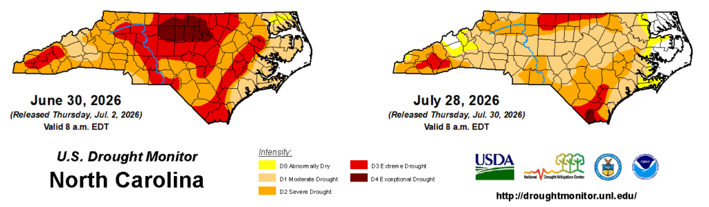
In our rain event recap, we hinted at drought improvements on the way. Those showed up on last week’s US Drought Monitor, with a significant decrease in Severe (D2) and Extreme (D3) Drought coverage, including two-category improvements in the wettest parts of the Piedmont.
That post also noted some of the ongoing signs of dryness, and reasons why we’re still in drought even after a wet month. Let’s take a closer look at these conditions, surveying many of the indicators reviewed each week by the North Carolina Drought Management Advisory Council.
Rainfall Deficits
Most of the state is still at least six inches below normal since the start of the year, but we’re no longer in driest-on-record territory in places like Raleigh, where the year-to-date deficit shrunk from 9.23 inches at the end of June to just 2.09 inches now. We’ve also seen a milestone out west, as Asheville is now slightly above its normal precipitation for the year.
But there are still some sizable shortfalls, including an 11.80-inch deficit in Wilmington, which is on pace for its 7th-driest start to a year, and a 13.27-inch deficit in Reidsville, which missed out on last month’s heavier rains along with other northern Piedmont areas that remain in Extreme Drought.
Streamflows
Our rivers and streams saw a nice recovery during our multi-day soaking rain event, and the good news is that they’ve mostly stayed near or above their normal levels, aided in part by more recent rounds of showers.
Since that event, we have seen streamflows decline in a few areas, including in the Sandhills and northern Coastal Plain. And the Tuckasegee River at Cullowhee and the Waccamaw River at Freeland – both areas that were drier than normal in July – are still seeing daily record low streamflow levels.

Lake Levels
With so much water flowing down our streams, our lakes and reservoirs also reaped the benefits. Notably, Jordan Lake reached its normal target, and Fontana Lake finally hit its summer guide curve after starting the summer more than 20 feet below that level.
Other reservoirs are still below their targets, but they’re in better shape now than earlier in the summer. Falls Lake rose by almost three feet and is now within three feet of its target level, while Lake Norman is two feet higher than its lowest point back in May, but about two feet short of its target.
Soil Moisture and Groundwater
The recent rain may have been most apparent in the wet ground and the green grass that’s suddenly flourishing, but some of that moisture has since soaked in or evaporated. By the end of July, topsoils in southeastern North Carolina began to dry out again, while deeper soils remained dry across the northern tier and Sandhills.
Our groundwater levels also show just how entrenched this drought has been. Even in the wettest areas like Mocksville, which had more than five inches of rain during our late-July event, the result was only a relatively small uptick in groundwater levels, which are still below the median for this time of year.

Agriculture
For farmers, this drought has presented an ongoing challenge, and that’s reflected in the latest USDA/NASS Crop Progress Report. It shows 39% of pastures in poor or very poor condition, largely because they missed out on needed rain after being planted last fall and winter. Early-planted corn also struggled through a hot, dry June, and July’s rain may have been too late to salvage it for the year.
However, other crops such as cotton, peanuts, and soybeans have seen their condition improve and their progress outpace the five-year average thanks to the recent rain. That’s a solid rebound after a drought-plagued start to the growing season.
Fire Danger
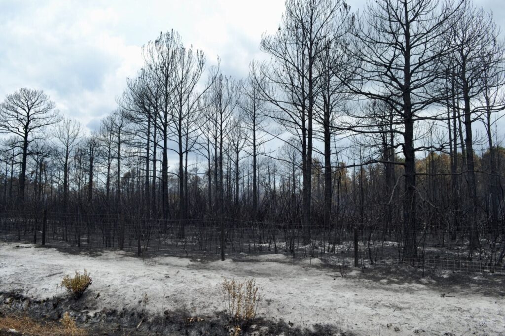
The summer months typically see less wildfire activity in our region due to the higher humidity and green vegetation that both holds onto moisture and provides cooling shade for the forest floor. But one part of the state is not immune to fires during summer droughts: the pocosin peat swamps that dot our coastline.
Sure enough, this summer brought several of those ignitions, including the 667-acre Rose Bay Canal fire in Hyde County and the 283-acre Quarry Road fire in Brunswick County. After July’s rain, those fires are at 100% and 90% containment, respectively.
Across all of these indicators, we see a clear message: July brought improvements, but not a full recovery from this drought’s ongoing impacts. However, we’re trending in the right direction, and instead of being one hot, dry week away from the next stage of water restrictions, cities such as Raleigh and Rocky Mount are beginning to roll back some of those measures.
That’s a refreshing reminder that this drought does have an expiration date, even if we’re not quite there yet.


Discussion about this post