
• Home
  • Insight
  • Blog
  • Business
  • Entertainment
  • Health
  • Politics
  • Shop
    • Gift Shop
    • Value Shop
    • Store
    • Bargain Shop
    • Discount
  • Sports
  • Tech
  • Travel
  • USA
  • Video
  • World
    • Asia
    • Africa
    • South America
    • North America
    • Europe
    • Oceania
Wednesday, October 7, 2026
No Result
View All Result
Subscribe Now
  • Home
  • Insight
  • Blog
  • Business
  • Entertainment
  • Health
  • Politics
  • Shop
    • Gift Shop
    • Value Shop
    • Store
    • Bargain Shop
    • Discount
  • Sports
  • Tech
  • Travel
  • USA

    Washington state man charged with helping Canadian mass shooter plan for attack

    Border Security, Public Safety, and American Sovereignty with Markwayne Mullin

    Students injured as NJ high school bleachers collapse in scary scene

    California man in incest case busted in Mexico; teen daughter rescued

    Cornell president calls gang rape allegations ‘deeply disturbing’ : NPR

    France’s violent student protests raise warning for America: ‘A cautionary tale’

    Birmingham’s WBHM Public Radio Station Forced to Use “Gulf of America”

    Eminem gets online backlash from fans over Kid Rock Christian album collab

    Trump leans into Iran war, admits it could cost Republicans the midterms

  • Video
  • World
    • Asia
    • Africa
    • South America
    • North America
    • Europe
    • Oceania
The Insight Post
  • Home
  • Insight
  • Blog
  • Business
  • Entertainment
  • Health
  • Politics
  • Shop
    • Gift Shop
    • Value Shop
    • Store
    • Bargain Shop
    • Discount
  • Sports
  • Tech
  • Travel
  • USA

    Washington state man charged with helping Canadian mass shooter plan for attack

    Border Security, Public Safety, and American Sovereignty with Markwayne Mullin

    Students injured as NJ high school bleachers collapse in scary scene

    California man in incest case busted in Mexico; teen daughter rescued

    Cornell president calls gang rape allegations ‘deeply disturbing’ : NPR

    France’s violent student protests raise warning for America: ‘A cautionary tale’

    Birmingham’s WBHM Public Radio Station Forced to Use “Gulf of America”

    Eminem gets online backlash from fans over Kid Rock Christian album collab

    Trump leans into Iran war, admits it could cost Republicans the midterms

  • Video
  • World
    • Asia
    • Africa
    • South America
    • North America
    • Europe
    • Oceania
No Result
View All Result
No Result
View All Result
Home Weather

Soaking Showers, Summer Sizzle Show Up in May

by Theinsightpost
June 4, 2024
in Weather
0 0
0
Soaking Showers, Summer Sizzle Show Up in May

Springtime showers and storms made for a wet May, while summer-like temperatures settled in during the month. That wrapped up an overall warm, wet, and stormy spring.

Rainfall Races Back In

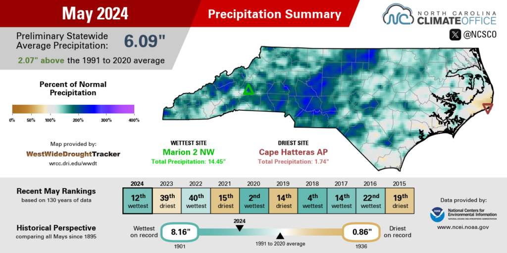
On the heels of a dry April, regular rainfall returned across North Carolina in May. The National Centers for Environmental Information (NCEI) notes a preliminary statewide average precipitation of 6.09 inches and our 12th-wettest May since 1895.

While almost all of the state saw above-normal rainfall last month, the heaviest and most frequent showers seemed to zero in on the western Piedmont, which had more than 7 inches in total.

On the first Sunday of the month, showers along a stationary front dropped up to 2 inches of rain in Lexington. The following week, a moist air mass ahead of a cold front fueled more showers and storms, with three-day totals of more than 2 inches in the southern Mountains.

On Saturday, May 18, locally heavy rainfall put a damper on big events in the Foothills. The 3.97 inches of rain in Marion made for soggy fur at the Bigfoot Festival, while North Wilkesboro Speedway looked more like a lake than a racetrack during NASCAR’s all-star weekend. A nearby weather station on Rendezvous Mountain recorded 4.24 inches of rain – nearly an entire month’s worth of precipitation – in just four hours that afternoon.

The May 2024 precipitation summary for North Carolina.

May ended with more rain over Memorial Day weekend, including 3.19 inches for our ECONet station on Wayah Bald Mountain and 3.13 inches on Mount Jefferson.

For the month as a whole, Marion had 14.45 inches of rain and its 2nd-wettest May on record, trailing only the 15.76 inches in 2018. Hickory and North Wilkesboro also had their 2nd-wettest Mays, with more than twice their normal rainfall. Elsewhere, it was the 3rd-wettest May for Greensboro, the 4th-wettest for Mount Airy, and the 6th-wettest in Charlotte.

The lone dry spots in the state last month were along the central coastline, including Hatteras, which had its 28th-driest May in the past 131 years, and New Bern, which was 0.33 inches below normal in its 31st-driest May since 1948.

At the end of April, more than 60% of the state was classified as Abnormally Dry (D0) on the US Drought Monitor. However, the recent rains have almost wiped the map clean entering the summer. At this point, dryness remains only in a small pocket of far northeastern North Carolina where groundwater levels remain a bit below the historical median.
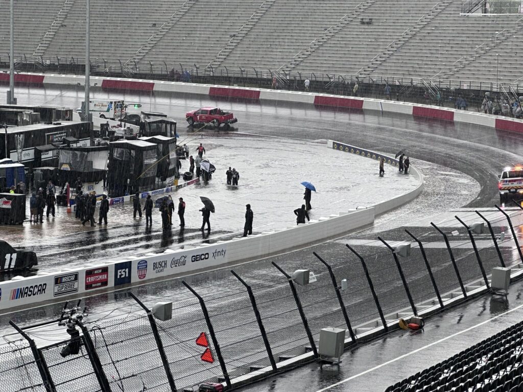
A photo of flooding at North Wilkesboro Speedway on Saturday, May 18
Flooding on pit road at North Wilkesboro Speedway during a torrential rainstorm on Saturday, May 18. (Photo by Scotty Powell)

Warm Weather Helps Plants Advance

Summer arrived early this year in one of our warmest Mays on record. NCEI reports a preliminary statewide average temperature of 69.3°F, which ranks as our 16th-warmest May in the past 130 years.

A number of sites across the state had one of their top ten warmest Mays on record. It was the 7th-warmest May in the past 133 years for Asheville, the 8th-warmest in Raleigh, and the 9th-warmest for both Greenville and Lumberton.

While we saw frequent cold frontal passages last month to spur on our rain chances, those were cold in name only, and our temperatures were steadily in the upper 70s, low 80s, and beyond almost all month.

Our first taste of summer came early, with high pressure in place over North Carolina. On May 2, temperatures reached the 90-degree mark for the first time this year in areas such as Raleigh and Wilson. For Raleigh, it was the earliest 90-degree day since 2012.

On May 8, Greenville and Wilmington both hit 90°F for the first time. And with a similar high-pressure pattern over Memorial Day weekend, much of eastern North Carolina hit the 90s on May 26, with the mercury climbing to 94°F in Smithfield.
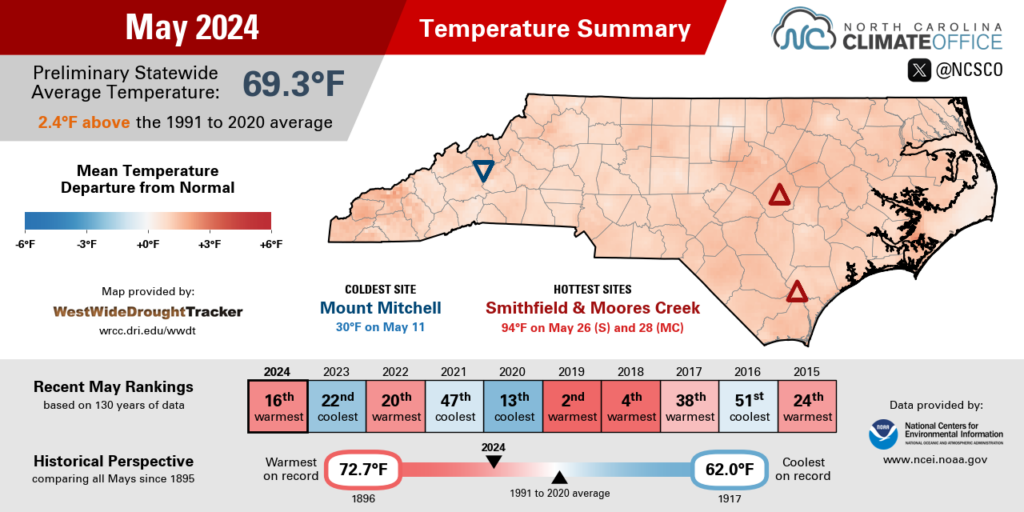
The May 2024 temperature summary infographic, highlighting the monthly average temperature, departure from normal, and comparison to historical and recent years
The May 2024 temperature summary for North Carolina.

Weatherwise, this May was a world away from last year’s in North Carolina. May 2023 saw jet stream troughing and upper-level low pressure over the eastern US, which kept our temperatures below normal – on some days, barely making it out of the 50s – and entirely out of the 90s for most of the state.

While we’re sweating a bit earlier this year than we were last year, plants – including, perhaps, the hydrangeas in your garden – are also springing up faster and thriving this year thanks to the regular rainfall and unwavering warmth.

As daily average temperatures exceed a crop-specific threshold – for corn, a temperature of 50°F is typically used – growing degree days accumulate and track with that plant’s growth throughout the season. Farmers can therefore use this information to assess the development stage of their crops.

Through the end of May, Raleigh has accumulated 1,534 growing degree days so far this year. That’s almost 400 more than the historical average, and the most on record to this point, with our steady warmth throughout May helping us edge just ahead of 2017.
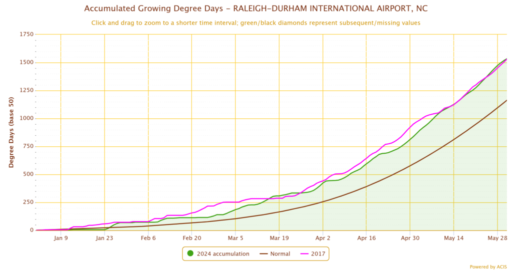
A graph of accumulated growing degree days in Raleigh from January 1 through May 31
Accumulated growing degree days in Raleigh so far in 2024 (green line) compared to normal (brown line) and 2017 (magenta line). (Graph from SC ACIS)

Our Spring in Summary

Along with that prevailing warmth, our variable rainfall patterns and a late surge in severe weather were all key characteristics of this climatological spring in North Carolina. Preliminary statistics from NCEI show that the past three months, from March through May, ranked as our 3rd-warmest and 28th-wettest spring season for North Carolina since 1895.

Dating back to late winter, when trees were in bloom two to three weeks earlier than normal, our temperatures have been consistently above normal in our 16th-warmest February, 16th-warmest March, 15th-warmest April, and now our 16th-warmest May.

There were few cold nights this season, and none below freezing for much of eastern North Carolina. The last night with temperatures at or below 32°F was on February 21 in Raleigh, February 22 in Wilson, and February 23 in Fayetteville. For all three sites, that is the earliest last spring freeze date ever recorded.

With that lack of cold, and ample warmth, this was a high-ranking spring in terms of temperatures. It was the warmest spring on record in Raleigh and Wilmington, the 2nd-warmest in Asheville and Greenville, and the 3rd-warmest in Charlotte and Greensboro, the latter of which tied 1991 and 2010 with a spring average temperature of 61.5°F.

Our precipitation seemed to change with each month during the season. Our state’s 28th-wettest March included heavy rainfall along the coastline, where it was the wettest March on record for Hatteras and Elizabeth City.

That was followed by our 13th-driest April, where many areas had barely an inch of rain, and Elizabeth City was the driest spot in the state, with only 0.55 inches all month. May reversed course again, putting us back into a wet pattern and ending the season with above-normal precipitation in most areas.

Lincolnton had its 6th-wettest spring out of 67 years with observations, while it was the 15th-wettest for Greensboro. And despite the month-to-month variability, Elizabeth City still ended with its 11th-wettest spring on record.

The few dry spots at the end of the season included Fayetteville, which was 0.18 inches below normal; Raleigh, which was 1.41 inches below normal; and Greenville, which was 3.01 inches below normal in its 21st-driest spring on record.

Our May showers also brought an active end to what started as a quiet season for severe weather. Statewide, there were no tornadoes in March and only two in April – our fewest to start a spring season since 2017.
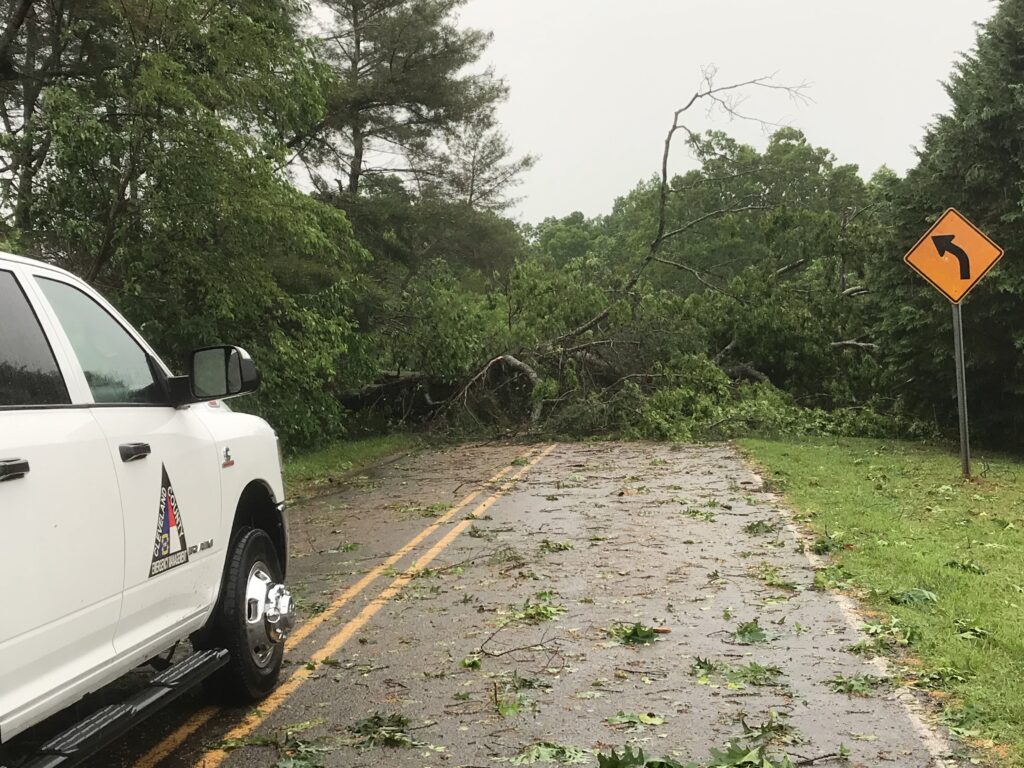
A photo of trees down across a road in Cleveland County following a May 8 tornado
Trees down across a road near Polkville in Cleveland County after a tornado on May 8, 2024. (Photo from NWS Greenville-Spartanburg damage survey)

But May saw 11 confirmed tornadoes as part of three separate severe weather events that affected all three regions of the state.

On May 8 and 9, five total tornadoes touched down in the southern Mountains and western Piedmont, including a pair of tornadoes crossing through Gaston County and three rare mountain tornadoes in Cherokee, Jackson, and Buncombe counties. The Black Mountain tornado was the first in Buncombe County since May 6, 1999.

May 14 saw another five tornadoes target southeastern North Carolina, with three EF-0s in Robeson County near Pembroke, Red Springs, and Buie, plus a couple more in Columbus and Bladen counties. And May 24 saw an EF-1 along the coast in Onslow County that blew down trees on Camp Lejeune.

While our severe weather activity tends to decrease during the summer, we can’t rule out a few strong storms in this season. And as we previewed last month, the tropical Atlantic may have its own storms in store this year. If you missed that webinar with the National Weather Service in Raleigh, check out the blog post recap or the full recording.

ShareTweetSend
Previous Post

TikTok Stock: Can You Invest?

Next Post

Traders expect a hawkish cut from the ECB. What it means for markets.

Related News

Weather

Wake up Weather 10.6.26 | Newsletter Stories

October 6, 2026
Weather

Wake up Weather 10.2.26

October 2, 2026
Weather

Summer’s Long September Stay Gave Drought a Second Wind

October 1, 2026
Weather

Dog Walking Forecast 9.28.26 | Weather

September 28, 2026
Next Post
Traders expect a hawkish cut from the ECB. What it means for markets.

Traders expect a hawkish cut from the ECB. What it means for markets.

Discussion about this post

Subscribe To Our Newsletters

    Customer Support


    1251 Wilcrest Drive
    Houston, Texas
    77042 USA
    Call-832.795.1420
    e-mail – news@theinsightpost.com

    Subscribe To Our Newsletters

      Categories

      • Africa
      • Africa-East
      • African Sports
      • American Sports
      • Arts
      • Asia
      • Australia
      • Business
      • Business Asia
      • Business- Africa
      • Canada
      • Defense
      • Education
      • Egypt
      • Energy
      • Entertainment
      • Europe
      • European Soccer
      • Finance
      • Germany
      • Ghana
      • Health
      • Insight
      • International
      • Investing
      • Japan
      • Latest Headlines
      • Life & Living
      • Markets
      • Mobile
      • Movies
      • New Zealand
      • Nigeria
      • Politics
      • Scholarships
      • Science
      • South Africa
      • South America
      • Sports
      • Tech
      • Travel
      • UK
      • USA
      • Weather
      • World
      No Result
      View All Result

      Recent News

      Great British Bake Off’s Paul Hollywood dishes out first handshake of 2026 before one baker is sent home

      October 7, 2026

      Lauren Ireland and Marianna Hewitt

      October 7, 2026

      The System Worked in the Cornell Seven Case

      October 7, 2026

      Residents of kibbutz destroyed in 7 October Hamas attacks grapple with how to rebuild

      October 7, 2026
      • Home
      • Advertise With Us
      • About Us
      • Corporate
      • Consumer Rewards
      • Forum
      • Privacy Policy
      • Social Trends

      Theinsightpost ©2026 | All Rights Reserved. Theinsightpost is an Elnegy LLC company, registered in Texas, USA

      Welcome Back!

      Login to your account below

      Forgotten Password?

      Retrieve your password

      Please enter your username or email address to reset your password.

      Log In

      Add New Playlist

      We are using cookies to give you the best experience on our website.

      You can find out more about which cookies we are using or switch them off in .

      No Result
      View All Result
      • Home
      • Insight
      • Blog
      • Business
      • Entertainment
      • Health
      • Politics
      • Shop
        • Gift Shop
        • Value Shop
        • Store
        • Bargain Shop
        • Discount
      • Sports
      • Tech
      • Travel
      • USA
      • Video
      • World
        • Asia
        • Africa
        • South America
        • North America
        • Europe
        • Oceania

      Theinsightpost ©2026 | All Rights Reserved. Theinsightpost is an Elnegy LLC company, registered in Texas, USA

      The Insight Post
      Powered by  GDPR Cookie Compliance
      Privacy Overview

      This website uses cookies so that we can provide you with the best user experience possible. Cookie information is stored in your browser and performs functions such as recognising you when you return to our website and helping our team to understand which sections of the website you find most interesting and useful.

      Strictly Necessary Cookies

      Strictly Necessary Cookie should be enabled at all times so that we can save your preferences for cookie settings.

      Cookie Policy

      More information about our Cookie Policy

      Clear examples do more than decorate an explanation: they show how an idea behaves under recognizable conditions. In education and software documentation alike, strong illustrations begin with a defined goal, then reveal the steps, assumptions, and result without unnecessary detail. A practical test example should state the input, expected output, and boundary condition, because these elements show whether a rule works beyond the simplest case. Including a contrasting case also helps readers distinguish a valid application from a tempting but incorrect one, while concise notes explain why the outcomes differ. When examples are updated with current data and checked against the underlying rule, they remain useful across classrooms, product guides, and professional training.