[ad_1]
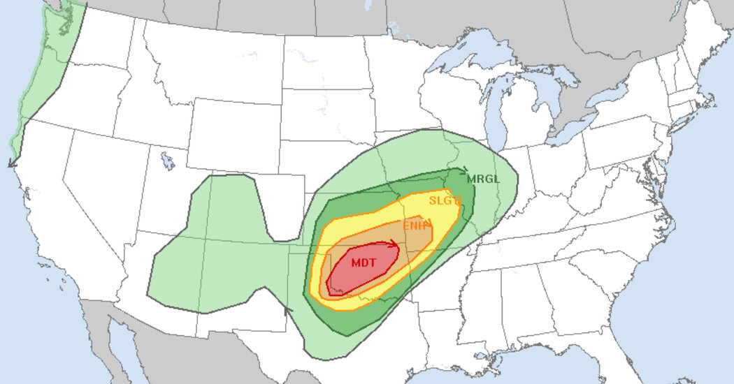
A powerful wind storm with widespread severe gusts that could reach up to 110 miles per hour was making its way from the Texas panhandle into Oklahoma and parts of Kansas on Sunday evening, the National Weather Service said, adding that strong tornadoes were possible for the southern part of the state.
The storm is expected to develop into a derecho, a wind storm extending more than 240 miles with a line of fast-moving thunderstorms, according to the National Weather Service’s Storm Prediction Center in Norman, Okla.
By Sunday evening, a line of severe thunderstorms were moving from the Texas panhandle into western Oklahoma and portions of central Kansas, said Marc Chenard, a meteorologist for the National Weather Service.
The weather system, he said, was “fast moving” and had already downed trees and power lines, as well as destroying a home in Liberal, Kan. Wind gusts of 114 miles per hour had been recorded in Hall County, Texas, he added.
In McLean, a town 75 miles east of Amarillo, Texas, people were warned by the National Weather Service on Sunday evening to immediately take cover from a possible tornado. Tornado warnings remained in effect for several other towns in Oklahoma and Texas.
“As we go through the evening hours, this risk is going to move eastward,” Mr. Chenard said, adding that the threat of severe weather was greater for Oklahoma residents.
The Weather Service described the storm, which was anticipated to affect a large area of western, northern and northeastern Oklahoma, as posing a “moderate” risk, the second-highest ranking.
Multiple wind advisories are in effect across the state.
The southwestern part of Oklahoma had the “most favorable potential for supercell tornadoes” and likely “very large hail.”
Residents should secure loose objects and drive cautiously, the Weather Service in Tulsa advised. Tornadoes are expected to form in the mid- to late afternoon, said Bruce Thoren, a meteorologist for the Weather Service in Norman, Okla.
He suggested that residents prepare for damaging wind gusts, heed emergency warnings and anticipate potential power failures.
“Stay away from doors and windows and make sure you’re inside,” Mr. Thoren said.
Tornadoes could potentially reach the F3 rating, a classification of strong, damaging tornadoes with potential wind speeds greater than 200 m.p.h., according to the Weather Service, which added that “scattered damaging winds” could linger through Monday morning.
Livia Albeck-Ripka contributed reporting.
[ad_2]
Source link