
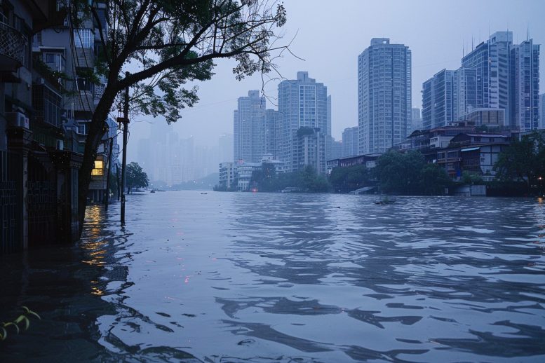
The Pearl River basin has experienced significant flooding events linked to climatic changes, with notable impacts on local ecology, agriculture, and society. A new study highlights the importance of understanding historical flood patterns to predict future events and their potential effects on human civilization.
River flooding is among the most catastrophic disasters worldwide. The Pearl River, the longest watercourse in southern China, particularly its lower reach with dense population and economic activity, has been identified as one of the world’s most vulnerable regions to flood exposure. Over 400 major flood disasters have been documented in the Pearl River basin over the past 2000 years. Model simulations even suggest that future surface warming can enhance both the intensity and frequency of extreme rainfall in this region.
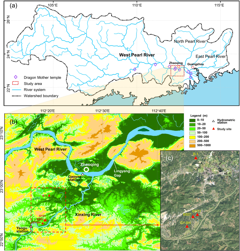
“The past is a clue to the future.” To assess the prediction of future catastrophic floods, an international team of scientists led by Prof. Zhuo Zheng (School of Earth Sciences and Engineering, Sun Yat-sen University) and Prof. Yongqiang Zong (Guangzhou Institute of Geography, Guangdong Academy of Sciences) sought to reconstruct the detailed history of great floods in the lower Pearl River area.
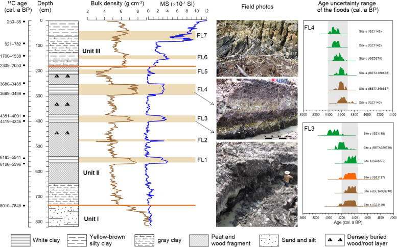
The identified clay flood layers are numbered from FL1–FL7 upward. Credit: Science China Press
Study Findings on Flood Deposits
In this study, Chen et al. report a series of white to gray clay layers interbedded sharply with wood-rich peat sediments in Gaoyao County, west of the Pearl River Delta. Through profile correlation, sedimentary analysis, and radiocarbon dating, they identified seven clay layers with 5–40 cm thickness during the past 6000 years, interpreted as flood deposits (designated FL1–FL7).
The study sites locate at the riparian hill land terrace near the river channel. Credit: Science China Press
These floods had an average return period of approximately 855 years, with an average water volume estimated to be 1.5 times that of the once-in-a-century Yimao Flood in July 1915.
Climatic Influences on Historical Flooding
The climatic background related to these great floods was found to match the period of weakening Asian summer monsoons, indicated by Chinese speleothem δ18O data and higher El Niño-Southern Oscillation (ENSO) frequency. Therefore, the authors suggest that the past great floods in the lower Pearl River area were possibly triggered by a weak summer monsoon and enhanced ENSO.
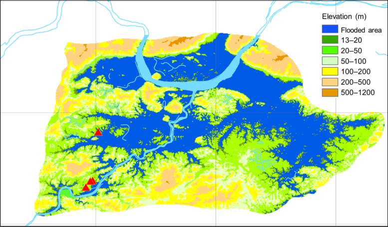
Inundated areas of the Holocene paleomegafloods based on the average water level (16 m). Credit: Science China Press
This mechanism is increasingly evidenced by modern meteorological observations, implying that southern China may face a significant risk of once-in-a-thousand-year flooding during periods of intensified ENSO amplitude in the future.
Impact of Flooding on Local Ecology and Agriculture
Pollen analysis was performed to reveal the tale of the Glyptostrobus wetland forest. The Glyptostrobus tree gradually expanded since 5200 years ago, becoming dominant after the FL3 event at 4200 years ago. However, the wetland forest abruptly declined at 2100 years ago, coinciding with the rise of intensive rice agriculture. Natural wetlands were ideal places for early paddy field rice farming, and the disappearance of Glyptostrobus in Southeast Asia serves as an intriguing example of how early rice agriculture could impact certain endemic 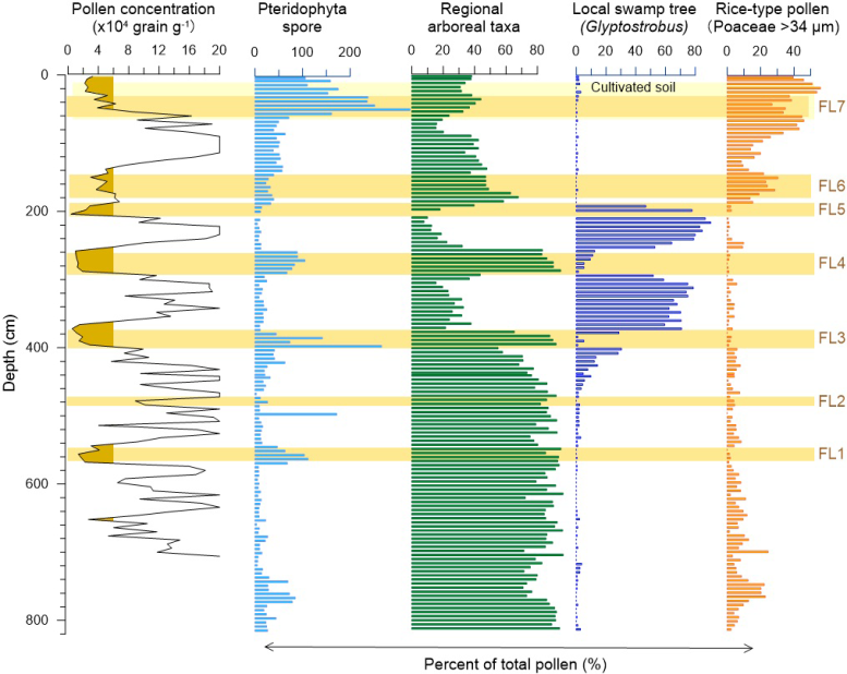
The Glyptostrobus wetland ecosystem could quickly recover after the floods. Credit: Science China Press
Furthermore, the earliest FL1 flood coincided with the demise of the Dingsishan culture approximately 6000 years ago. Megafloods also play a central role in some famous tales or old legends. In the Pearl River basin, the Dragon Mother is worshipped as a water god and protector against floods. The origin of this worship culture can be traced back to the Qin Dynasty (221–207 BC), fitting chronologically with the FL5 flood. The FL7 flood coincided with the beginning of levee construction along the local West Pearl River during the Song Dynasty. The authors argue that the recurrent megafloods had noticeable impacts on the development of local civilization and human society in the Pearl River basin.
Reference: “Holocene millennial-scale megaflood events point to ENSO-driven extreme climate changes” by Cong Chen, Yanwei Zheng, Zhuo Zheng, Yongqiang Zong, Kangyou Huang, Barry V. Rolett, Huanhuan Peng, Xiao Zhang, Yongjie Tang, Qiuchi Wan, Guifang Zhang and Rachid Chedaddi, 24 October 2023, Science China Earth Sciences.
DOI: 10.1007/s11430-023-1196-y
