[ad_1]
While the primary threat will be damaging winds, a couple of tornadoes are possible after dark, with a focus on an area that includes the Houston Metro.
Severe thunderstorms and flooding rainfall will threaten areas from Texas and the southern Plains to the Mississippi Valley and Deep South early this week as a cold front teams up with tropical moisture from former Hurricane Roslyn to create a ripe environment for storms.
While Roslyn’s circulation has dissipated over Mexico, its limited moisture and upper-level energy are being pulled northward by the advancing cold front and overspreading the south-central U.S.
Rain developed Monday morning across the southern Plains and will expand into the mid-Mississippi Valley on Monday afternoon as the cold front slides east. By Monday night, the FOX Forecast Center said, the cold front will be reinforced by a powerful storm system pushing out of the northern Plains, which brought high winds and accumulating snow over the weekend.
HOW TO WATCH FOX WEATHER

(FOX Weather)
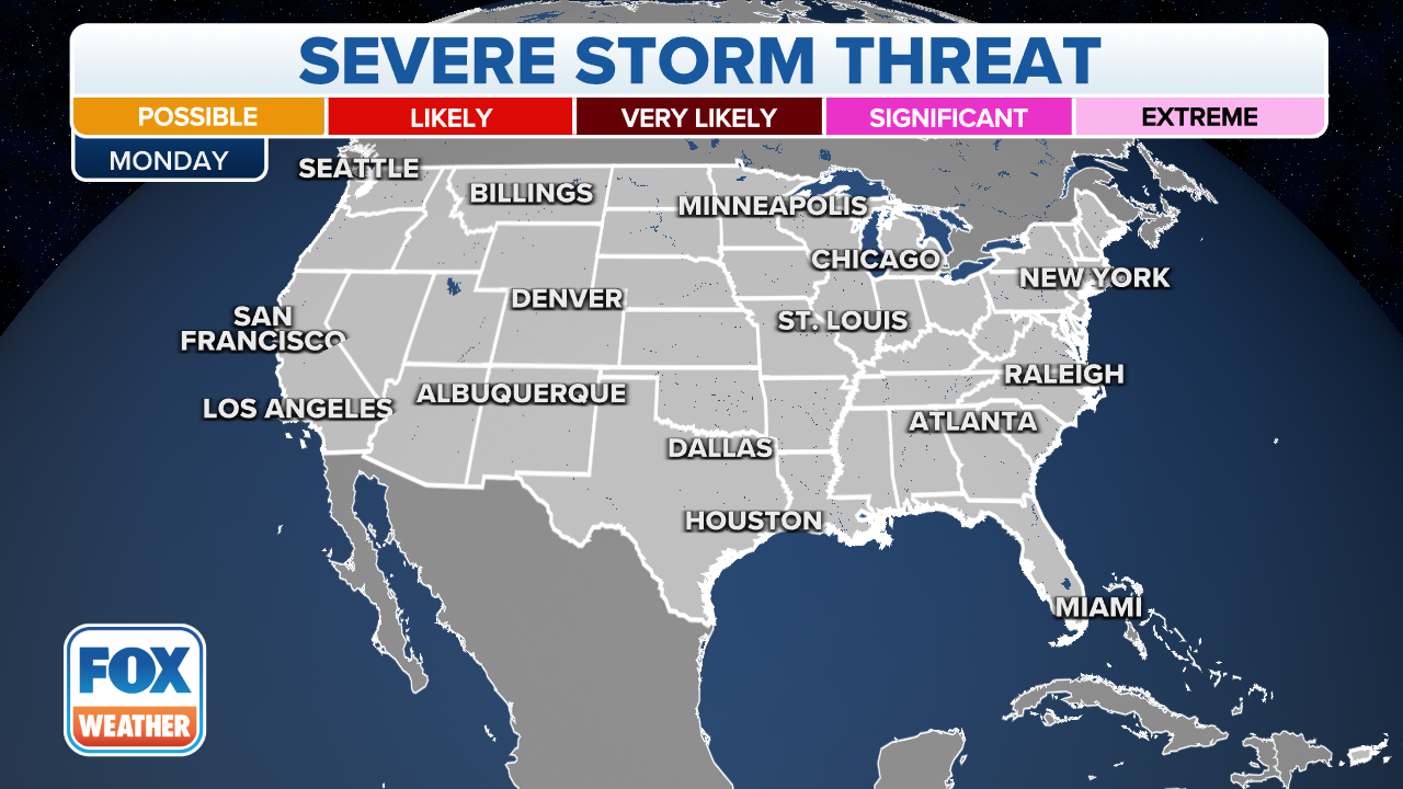
Monday’s severe storm threat
Severe thunderstorms are possible Monday and Monday night from Central and East Texas eastward to the middle and upper Texas coast, the Ark-La-Tex and far western Louisiana. This includes the Dallas, Houston, Austin and San Antonio metro areas.
Damaging wind gusts are the main threat with these storms, but a couple of tornadoes are also possible, including after dark.
“The issue with severe weather at night, of course, it’s too dark to see anything, so if something does pop up, like a tornado, within any of this area, it’s going to be blowing through while you are sleeping,” FOX Weather meteorologist Britta Merwin explained. “Also, we have fewer spotters that are outside. A lot of times when we are tracking Tornado Warnings, we rely on those spotter reports to really know if we have something on the ground, and it helps us track that tornado as it rolls through towns. That’s not really an option if everybody is already at home sleeping.”
NIGHTTIME TORNADOES FAR MORE LIKELY TO TURN DEADLY THAN DAYTIME ONES
(FOX Weather)
Tuesday’s severe storm threat
Strong to severe thunderstorms are expected Tuesday from the lower Mississippi Valley and mid-South to the Deep South. This includes cities such as Memphis in Tennessee, Baton Rouge in Louisiana and Birmingham, Montgomery and Mobile in Alabama.
Damaging wind gusts are the primary threat, but a couple of tornadoes are possible as well.
“Something that you want to consider … is making sure that you have an easy way to get your family to that safe spot – an interior bathroom or a closet,” Merwin said. “Most folks (in some Southern states) don’t have a basement … so it’s a good idea to make sure that you know where that safe location is.”
TORNADO SAFETY: HOW TO IDENTIFY THE SAFEST PLACES INSIDE YOUR HOME

(FOX Weather)
Heavy rain threat in southern Plains, lower and mid-Mississippi Valley
Aside from the severe weather, the FOX Forecast Center will also be monitoring the threat of heavy rainfall that could result in flash flooding early this week.
A widespread area of 1 to 3 inches of rain is expected from Texas and Oklahoma to the lower and mid-Mississippi Valley. Isolated amounts higher than 3 inches are possible in some locations.
While the rain will be beneficial to many communities that are experiencing drought conditions, flash flooding could become a concern if too much rain falls in a short period of time.
HOW BAD WILL WINTER BE? NOAA PREDICTS LA NINA WILL PLAY ROLE IN SEASON’S WEATHER FOR 3RD STRAIGHT WINTER

(FOX Weather)
Rain provides drought relief to parched central US
Nearly 95% of the region spanning the states of Texas, Oklahoma, Louisiana, Arkansas, Mississippi and Tennessee is currently experiencing drought conditions, with many areas seeing a rainfall deficit of more than 10 inches for the year.
The lack of rain has caused some tributaries of the Mississippi River to dry up, and a nearly 400-mile stretch of the waterway is at extremely low levels.
By Wednesday, some spots that desperately need the rainfall will have picked up several inches of precipitation.
SALTWATER CREEPING UP MISSISSIPPI RIVER AMID LOWEST LEVELS IN A DECADE

(FOX Weather)
The FOX Forecast Center said the rain would not be enough to restore river levels, but it will likely stop the waterline from dropping further.
After the early-week system heads eastward, the next significant chance of rain isn’t expected to arrive until the end of the workweek.
[ad_2]
Source link
