
[ad_1]

Here’s our latest weather forecast for India
Monday (August 22)
- Heavy to very heavy rainfall with extremely heavy falls at isolated places is very likely over East Rajasthan and West Madhya Pradesh.
- Heavy to very heavy rainfall is possible in isolated places over Madhya Maharashtra.
- Heavy rainfall is expected at isolated places over south Haryana, East Madhya Pradesh, Andaman & Nicobar Islands, Assam, Meghalaya, Nagaland, Manipur, Mizoram, Tripura, Gujarat, Konkan, Goa and coastal Karnataka.
- Thunderstorms accompanied by lightning in isolated places has been forecast over Jammu, Kashmir, Ladakh, Gilgit, Baltistan, Muzaffarabad, Himachal Pradesh, Uttarakhand, Punjab, Haryana, Chandigarh, Delhi, Uttar Pradesh, Rajasthan, Andaman & Nicobar Islands, Assam, Meghalaya, Nagaland, Manipur, Mizoram, Tripura, Gujarat, Tamil Nadu, Puducherry, Karaikal, Kerala, Mahe and Lakshadweep.
Tuesday (August 23)
- Heavy to very heavy rainfall at isolated places is very likely over Rajasthan and Gujarat.
- Heavy rainfall at isolated places is possible over Himachal Pradesh, Gangetic West Bengal, Odisha, Assam, Meghalaya, Nagaland, Manipur, Mizoram, Tripura, Madhya Maharashtra, South Interior Karnataka, Tamil Nadu, Puducherry, Karaikal, Kerala and Mahe.
- Thunderstorms accompanied by lightning have been forecast at isolated places over Jammu, Kashmir, Ladakh, Gilgit, Baltistan, Muzaffarabad, Himachal Pradesh, Uttarakhand, Punjab, Haryana, Chandigarh, Delhi, Uttar Pradesh, Rajasthan, Madhya Pradesh, Vidarbha, Chhattisgarh, Jharkhand, West Bengal, Sikkim, Odisha, Gujarat, Kerala, Mahe and Lakshadweep.
5-Day Nationwide Forecast
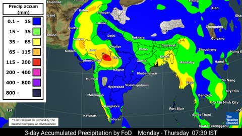
3-day rainfall forecast from Monday to Thursday
(TWC Met Team)
The depression over Northeast Madhya Pradesh moved westwards during the past six hours and lay centred over central parts of Madhya Pradesh and adjoining south Uttar Pradesh, about 60 km north of Sagar (Madhya Pradesh), 70 km west-northwest of Damoh (Madhya Pradesh) and 115 km south-southeast of Jhansi (Uttar Pradesh). It will continue to move west-northwestwards across northwest Madhya Pradesh and weaken into a well-marked low-pressure area during the next 12 hours. Additionally, the monsoon trough now runs from Amritsar, Karnal, Delhi, the centre of depression over central parts of Madhya Pradesh and adjoining south Uttar Pradesh, Sidhi, Daltonganj, Jamshedpur, Kharagpur, Digha and thence east-southeastwards to the northeast Bay of Bengal.
Fairly widespread to widespread light or moderate rainfall with isolated heavy to very heavy rainfall with extremely heavy falls is very likely over West Madhya Pradesh and East Rajasthan on Monday. Additionally, fairly widespread to widespread light or moderate rainfall with isolated heavy to very heavy falls accompanied by thunderstorms and lightning is possible over ghat areas of Madhya Maharashtra on Monday, East Rajasthan, West Rajasthan and northern parts of Gujarat on Tuesday.
Fairly widespread to widespread light or moderate rainfall with isolated heavy falls accompanied by thunderstorms and lightning is expected over Konkan, Goa, East Madhya Pradesh and northern parts of Gujarat on Monday, West Rajasthan on Monday and Wednesday, Gangetic West Bengal, ghat areas of Madhya Maharashtra and Odisha on Tuesday, and Saurashtra and Kutch on Wednesday.
In addition, fairly widespread to widespread light or moderate rainfall with isolated heavy falls accompanied by thunderstorms and lightning has been forecast over south Haryana on Monday, Himachal Pradesh on Tuesday and Wednesday, and Uttarakhand on Wednesday.
Fairly widespread to widespread light or moderate rainfall with isolated heavy falls accompanied by thunderstorms and lightning is on the cards over Assam, Meghalaya, Nagaland, Manipur, Mizoram and Tripura on Tuesday and Wednesday.
Furthermore, fairly widespread to widespread light or moderate rainfall with isolated heavy falls accompanied by thunderstorms and lightning has been predicted over coastal Andhra Pradesh and Yanam on Friday, coastal Karnataka on Monday, Wednesday, Thursday and Friday, South Interior Karnataka, Kerala, Mahe, Tamil Nadu, Puducherry and Karaikal from Tuesday to Friday.
Widespread light or moderate rainfall with isolated heavy falls accompanied by thunderstorms and lightning is very likely over Andaman & Nicobar Islands on Monday.
**
For weather, science, space, and COVID-19 updates on the go, download The Weather Channel App (on Android and iOS store). It’s free!
[ad_2]
Source link
